Imst elevation
Imst (Tyrol, Politischer Bezirk Imst), Austria elevation is 823 meters and Imst elevation in feet is 2700 ft above sea level [src 1]. Imst is a seat of a third-order administrative division (feature code) with elevation that is 314 meters (1030 ft) bigger than average city elevation in Austria.
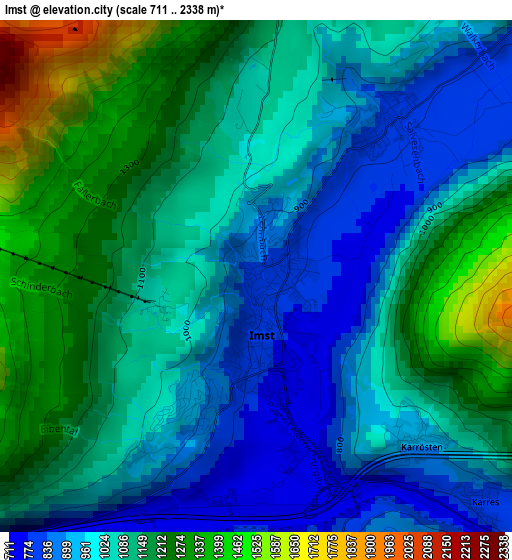
Below is the Elevation map of Imst, which displays elevation range with different colors. Scale of the first map is from 711 to 2338 m (2333 to 7671 ft) with average elevation of 1072.7 meters (=3519 ft) [note 1]
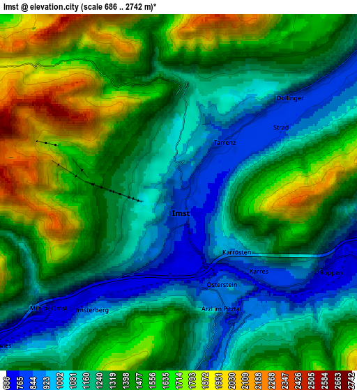
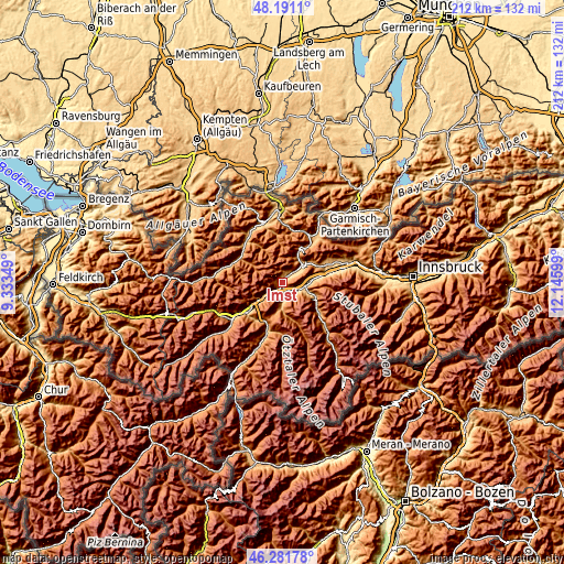
These maps also provides idea of topography and contour of this city, they are displayed at different zoom levels. More info about maps, scale and edge coordinates you can find below images.
| \ | Map #1 | Map #2 | Topo.Map |
| Scale [m] | 711..2338 m | 686..2742 m | × |
| Scale [ft] | 2333..7671 ft | 2251..8996 ft | × |
| Average | 1072.7 m = 3519 ft | 1357 m = 4452 ft | × |
| Width | 6.63 km = 4.1 mi | 13.27 km = 8.2 mi | 212.3 km = 131.9 mi |
| Height | 6.63 km = 4.1 mi | 13.27 km = 8.2 mi | 212.3 km = 131.9 mi |
| ↑Max Latitude | 47.274865° | 47.304672° | 48.1911° |
| Latitude at center | 47.24504° | 47.24504° | 47.24504° |
| ↓Min Latitude | 47.215199° | 47.185341° | 46.28178° |
| ← Min Longitude | 10.695795° | 10.651849° | 9.33349° |
| Longitude center | 10.73974° | 10.73974° | 10.73974° |
| →Max Longitude | 10.783685° | 10.827631° | 12.14599° |
Nearby cities:
Cities around Imst sort by population:
• Nassereith elevation 842 m
10.6 km,  41°
41°
• Wenns 956 m
8.7 km,  183°
183°
• Arzl im Pitztal 854 m
4.6 km,  157°
157°
• Tarrenz 816 m
3.1 km, 40°
• Roppen 695 m
6.6 km,  118°
118°
• Schönwies 738 m
8.2 km,  229°
229°
• Ötztal-Bahnhof 722 m
8.4 km,  98°
98°
• Jerzens 1126 m
10.4 km, 177°
• Imsterberg 899 m
5.5 km,  216°
216°
• Karrösten 905 m
2.9 km,  138°
138°
• Karres 814 m
4.6 km,  133°
133°
• Mils bei Imst 733 m
6.5 km, 228°
Multilingual:
 En español:
Imst elevación 823 m.
 En France:
Imst élévation 823 m.


Sources and notes:
- [note 1] Map square and city borders are not equal. Map elevation data is calculated only from area inside that square.
- [src 1] Elevation data from geonames database provided with same terms of usage.
- [src 2] The elevation map of Imst is generated using elevation data from NASA's 3 arcsec (90m) resolution SRTM data.
- [src 3] Base (background) map © OpenStreetMap contributors tiles are generated by Geofabrik and OpenTopoMap.
Copyright & License:
This Imst Elevation Map is licensed under CC BY-SA. You may reuse any part from this page, if you give a proper credit by linking to this URL:
 More info on terms of use page.