Alland elevation
Alland (Lower Austria, Politischer Bezirk Baden), Austria elevation is 325 meters and Alland elevation in feet is 1066 ft above sea level [src 1]. Alland is a seat of a third-order administrative division (feature code) with elevation that is 184 meters (604 ft) smaller than average city elevation in Austria.
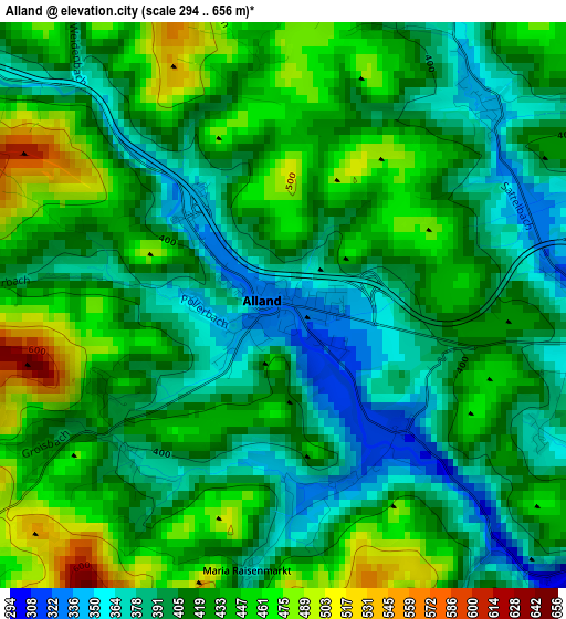
Below is the Elevation map of Alland, which displays elevation range with different colors. Scale of the first map is from 294 to 656 m (965 to 2152 ft) with average elevation of 418.8 meters (=1374 ft) [note 1]
These maps also provides idea of topography and contour of this city, they are displayed at different zoom levels. More info about maps, scale and edge coordinates you can find below images.
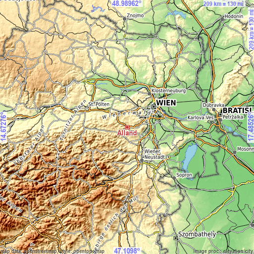
| \ | Map #1 | Topo.Map |
| Scale [m] | 294..656 m | × |
| Scale [ft] | 965..2152 ft | × |
| Average | 418.8 m = 1374 ft | × |
| Width | 6.53 km = 4.1 mi | 209 km = 129.9 mi |
| Height | 6.53 km = 4.1 mi | 209 km = 129.9 mi |
| ↑Max Latitude | 48.087654° | 48.98962° |
| Latitude at center | 48.05829° | 48.05829° |
| ↓Min Latitude | 48.02891° | 47.1098° |
| ← Min Longitude | 16.035065° | 14.67276° |
| Longitude center | 16.07901° | 16.07901° |
| →Max Longitude | 16.122955° | 17.48526° |
Nearby cities:
Cities around Alland sort by population:
• Berndorf elevation 311 m
12.7 km,  169°
169°
• Breitenfurt bei Wien 339 m
9.9 km,  32°
32°
• Kaltenleutgeben 335 m
11 km,  54°
54°
• Pottenstein 324 m
11.2 km, 173°
• Gießhübl 416 m
12.4 km,  69°
69°
• Wolfsgraben 323 m
11.6 km,  15°
15°
• Klausen-Leopoldsdorf 373 m
5.7 km,  305°
305°
• Gaaden 318 m
9 km,  93°
93°
• Weissenbach an der Triesting 357 m
9 km,  199°
199°
• Altenmarkt an der Triesting 393 m
7.8 km,  232°
232°
• Heiligenkreuz 355 m
3.4 km,  95°
95°
• Furth an der Triesting 425 m
12.3 km,  219°
219°
Multilingual:
 En español:
Alland elevación 325 m.
 En France:
Alland élévation 325 m.


Sources and notes:
- [note 1] Map square and city borders are not equal. Map elevation data is calculated only from area inside that square.
- [src 1] Elevation data from geonames database provided with same terms of usage.
- [src 2] The elevation map of Alland is generated using elevation data from NASA's 3 arcsec (90m) resolution SRTM data.
- [src 3] Base (background) map © OpenStreetMap contributors tiles are generated by Geofabrik and OpenTopoMap.
Copyright & License:
This Alland Elevation Map is licensed under CC BY-SA. You may reuse any part from this page, if you give a proper credit by linking to this URL:
 More info on terms of use page.