Pottenstein elevation
Pottenstein (Lower Austria, Politischer Bezirk Baden), Austria elevation is 324 meters and Pottenstein elevation in feet is 1063 ft above sea level [src 1]. Pottenstein is a seat of a third-order administrative division (feature code) with elevation that is 185 meters (607 ft) smaller than average city elevation in Austria.
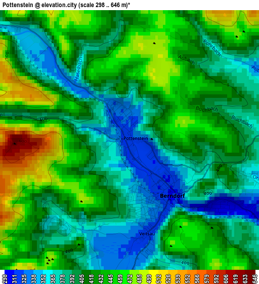
Below is the Elevation map of Pottenstein, which displays elevation range with different colors. Scale of the first map is from 298 to 646 m (978 to 2119 ft) with average elevation of 414.1 meters (=1359 ft) [note 1]
These maps also provides idea of topography and contour of this city, they are displayed at different zoom levels. More info about maps, scale and edge coordinates you can find below images.
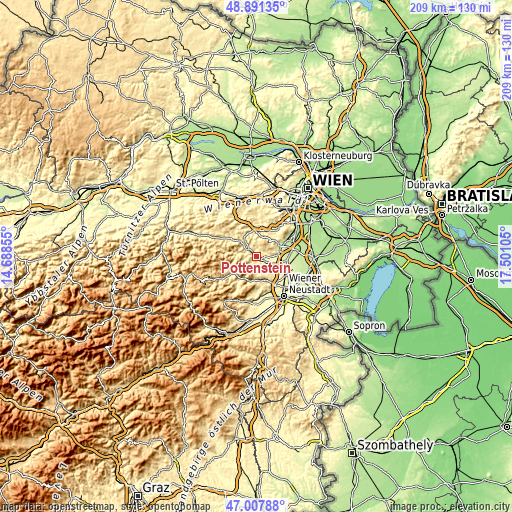
| \ | Map #1 | Topo.Map |
| Scale [m] | 298..646 m | × |
| Scale [ft] | 978..2119 ft | × |
| Average | 414.1 m = 1359 ft | × |
| Width | 6.54 km = 4.1 mi | 209.4 km = 130.1 mi |
| Height | 6.54 km = 4.1 mi | 209.4 km = 130.1 mi |
| ↑Max Latitude | 47.987621° | 48.89135° |
| Latitude at center | 47.9582° | 47.9582° |
| ↓Min Latitude | 47.928763° | 47.00788° |
| ← Min Longitude | 16.050855° | 14.68855° |
| Longitude center | 16.0948° | 16.0948° |
| →Max Longitude | 16.138745° | 17.50105° |
Nearby cities:
Cities around Pottenstein sort by population:
• Berndorf elevation 311 m
1.8 km,  141°
141°
• Bad Vöslau 262 m
8.9 km,  84°
84°
• Kottingbrunn 252 m
9.9 km,  94°
94°
• Leobersdorf 267 m
9.7 km,  110°
110°
• Gainfarn 280 m
7.4 km, 86°
• Hirtenberg 282 m
7 km,  115°
115°
• Markt Piesting 335 m
9.7 km,  166°
166°
• Sooss 246 m
9.6 km,  72°
72°
• Weissenbach an der Triesting 357 m
4.9 km,  302°
302°
• Altenmarkt an der Triesting 393 m
9.7 km,  311°
311°
• Hernstein 436 m
7.1 km, 173°
• Furth an der Triesting 425 m
9.2 km,  280°
280°
Multilingual:
 En español:
Pottenstein elevación 324 m.
 En France:
Pottenstein élévation 324 m.
 Auf Deutsch:
Pottenstein höhe über dem Meeresspiegel ist 324 m.

Sources and notes:
- [note 1] Map square and city borders are not equal. Map elevation data is calculated only from area inside that square.
- [src 1] Elevation data from geonames database provided with same terms of usage.
- [src 2] The elevation map of Pottenstein is generated using elevation data from NASA's 3 arcsec (90m) resolution SRTM data.
- [src 3] Base (background) map © OpenStreetMap contributors tiles are generated by Geofabrik and OpenTopoMap.
Copyright & License:
This Pottenstein Elevation Map is licensed under CC BY-SA. You may reuse any part from this page, if you give a proper credit by linking to this URL:
 More info on terms of use page.