Gaaden elevation
Gaaden (Lower Austria, Politischer Bezirk Mödling), Austria elevation is 318 meters and Gaaden elevation in feet is 1043 ft above sea level [src 1]. Gaaden is a seat of a third-order administrative division (feature code) with elevation that is 191 meters (627 ft) smaller than average city elevation in Austria.
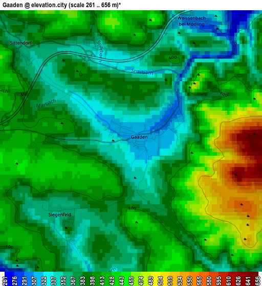
Below is the Elevation map of Gaaden, which displays elevation range with different colors. Scale of the first map is from 261 to 656 m (856 to 2152 ft) with average elevation of 398.6 meters (=1308 ft) [note 1]
These maps also provides idea of topography and contour of this city, they are displayed at different zoom levels. More info about maps, scale and edge coordinates you can find below images.
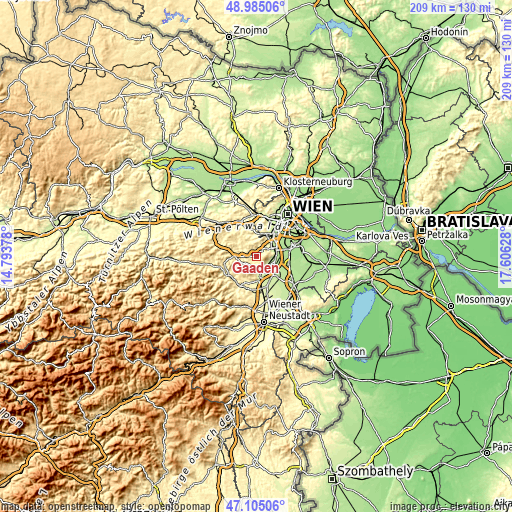
| \ | Map #1 | Topo.Map |
| Scale [m] | 261..656 m | × |
| Scale [ft] | 856..2152 ft | × |
| Average | 398.6 m = 1308 ft | × |
| Width | 6.53 km = 4.1 mi | 209 km = 129.9 mi |
| Height | 6.53 km = 4.1 mi | 209 km = 129.9 mi |
| ↑Max Latitude | 48.083006° | 48.98506° |
| Latitude at center | 48.05364° | 48.05364° |
| ↓Min Latitude | 48.024257° | 47.10506° |
| ← Min Longitude | 16.156085° | 14.79378° |
| Longitude center | 16.20003° | 16.20003° |
| →Max Longitude | 16.243975° | 17.60628° |
Nearby cities:
Cities around Gaaden sort by population:
• Baden elevation 230 m
5.9 km,  155°
155°
• Mödling 222 m
7.5 km,  61°
61°
• Maria Enzersdorf 223 m
8.1 km,  50°
50°
• Traiskirchen 204 m
8.2 km,  121°
121°
• Gumpoldskirchen 244 m
5.8 km,  99°
99°
• Tribuswinkel 211 m
7.4 km,  135°
135°
• Hinterbrühl 254 m
5.1 km,  44°
44°
• Pfaffstätten 217 m
6.2 km,  130°
130°
• Kaltenleutgeben 335 m
7 km,  359°
359°
• Gießhübl 416 m
5.5 km,  27°
27°
• Sooss 246 m
7.8 km,  170°
170°
• Heiligenkreuz 355 m
5.6 km,  272°
272°
Multilingual:
 En español:
Gaaden elevación 318 m.
 En France:
Gaaden élévation 318 m.


Sources and notes:
- [note 1] Map square and city borders are not equal. Map elevation data is calculated only from area inside that square.
- [src 1] Elevation data from geonames database provided with same terms of usage.
- [src 2] The elevation map of Gaaden is generated using elevation data from NASA's 3 arcsec (90m) resolution SRTM data.
- [src 3] Base (background) map © OpenStreetMap contributors tiles are generated by Geofabrik and OpenTopoMap.
Copyright & License:
This Gaaden Elevation Map is licensed under CC BY-SA. You may reuse any part from this page, if you give a proper credit by linking to this URL:
 More info on terms of use page.