Gumpoldskirchen elevation
Gumpoldskirchen (Lower Austria, Politischer Bezirk Mödling), Austria elevation is 244 meters and Gumpoldskirchen elevation in feet is 801 ft above sea level [src 1]. Gumpoldskirchen is a seat of a third-order administrative division (feature code) with elevation that is 265 meters (869 ft) smaller than average city elevation in Austria.
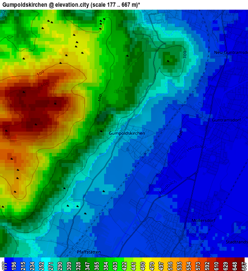
Below is the Elevation map of Gumpoldskirchen, which displays elevation range with different colors. Scale of the first map is from 177 to 667 m (581 to 2188 ft) with average elevation of 306.5 meters (=1006 ft) [note 1]
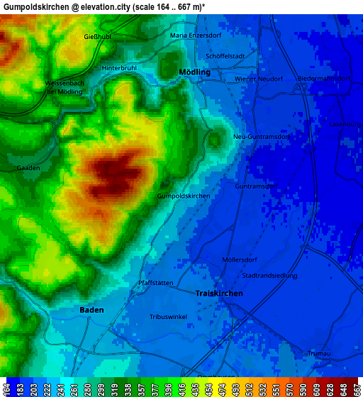
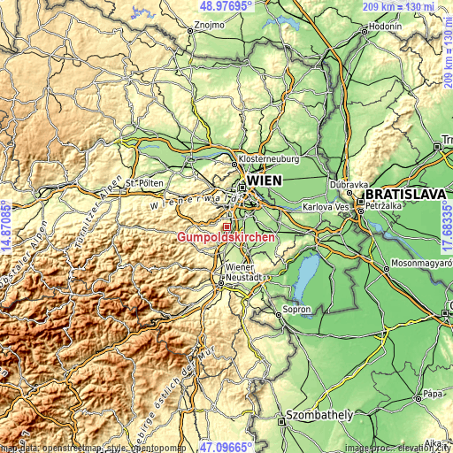
These maps also provides idea of topography and contour of this city, they are displayed at different zoom levels. More info about maps, scale and edge coordinates you can find below images.
| \ | Map #1 | Map #2 | Topo.Map |
| Scale [m] | 177..667 m | 164..667 m | × |
| Scale [ft] | 581..2188 ft | 538..2188 ft | × |
| Average | 306.5 m = 1006 ft | 278.6 m = 914 ft | × |
| Width | 6.53 km = 4.1 mi | 13.07 km = 8.1 mi | 209.1 km = 129.9 mi |
| Height | 6.53 km = 4.1 mi | 13.07 km = 8.1 mi | 209.1 km = 129.9 mi |
| ↑Max Latitude | 48.074751° | 48.104105° | 48.97695° |
| Latitude at center | 48.04538° | 48.04538° | 48.04538° |
| ↓Min Latitude | 48.015992° | 47.986588° | 47.09665° |
| ← Min Longitude | 16.233155° | 16.189209° | 14.87085° |
| Longitude center | 16.2771° | 16.2771° | 16.2771° |
| →Max Longitude | 16.321045° | 16.364991° | 17.68335° |
Nearby cities:
Cities around Gumpoldskirchen sort by population:
• Baden elevation 230 m
5.5 km,  216°
216°
• Mödling 222 m
4.6 km,  11°
11°
• Wiener Neudorf 202 m
5 km,  33°
33°
• Guntramsdorf 188 m
2.7 km,  86°
86°
• Neu-Guntramsdorf 192 m
3.6 km,  53°
53°
• Traiskirchen 204 m
3.6 km,  160°
160°
• Möllersdorf 194 m
3 km,  136°
136°
• Tribuswinkel 211 m
4.4 km,  186°
186°
• Hinterbrühl 254 m
5 km,  334°
334°
• Pfaffstätten 217 m
3.3 km,  197°
197°
• Wienersdorf 204 m
4.3 km,  165°
165°
• Gaaden 318 m
5.8 km,  279°
279°
Multilingual:
 En español:
Gumpoldskirchen elevación 244 m.
 En France:
Gumpoldskirchen élévation 244 m.
 Auf Deutsch:
Gumpoldskirchen höhe über dem Meeresspiegel ist 244 m.

Sources and notes:
- [note 1] Map square and city borders are not equal. Map elevation data is calculated only from area inside that square.
- [src 1] Elevation data from geonames database provided with same terms of usage.
- [src 2] The elevation map of Gumpoldskirchen is generated using elevation data from NASA's 3 arcsec (90m) resolution SRTM data.
- [src 3] Base (background) map © OpenStreetMap contributors tiles are generated by Geofabrik and OpenTopoMap.
Copyright & License:
This Gumpoldskirchen Elevation Map is licensed under CC BY-SA. You may reuse any part from this page, if you give a proper credit by linking to this URL:
 More info on terms of use page.