Arnreit elevation
Arnreit (Upper Austria, Politischer Bezirk Rohrbach), Austria elevation is 604 meters and Arnreit elevation in feet is 1982 ft above sea level [src 1]. Arnreit is a seat of a third-order administrative division (feature code) with elevation that is 95 meters (312 ft) bigger than average city elevation in Austria.
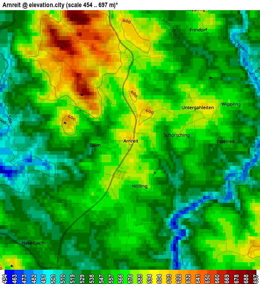
Below is the Elevation map of Arnreit, which displays elevation range with different colors. Scale of the first map is from 454 to 697 m (1490 to 2287 ft) with average elevation of 556.2 meters (=1825 ft) [note 1]
These maps also provides idea of topography and contour of this city, they are displayed at different zoom levels. More info about maps, scale and edge coordinates you can find below images.
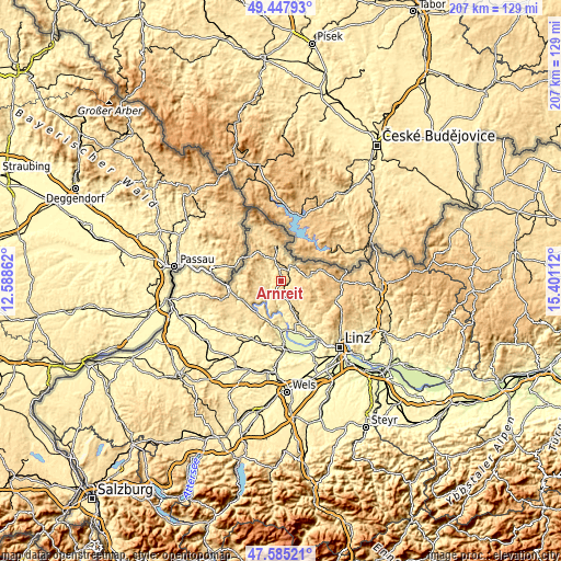
| \ | Map #1 | Topo.Map |
| Scale [m] | 454..697 m | × |
| Scale [ft] | 1490..2287 ft | × |
| Average | 556.2 m = 1825 ft | × |
| Width | 6.47 km = 4 mi | 207.1 km = 128.7 mi |
| Height | 6.47 km = 4 mi | 207.1 km = 128.7 mi |
| ↑Max Latitude | 48.554226° | 49.44793° |
| Latitude at center | 48.52513° | 48.52513° |
| ↓Min Latitude | 48.496017° | 47.58521° |
| ← Min Longitude | 13.950925° | 12.58862° |
| Longitude center | 13.99487° | 13.99487° |
| →Max Longitude | 14.038815° | 15.40112° |
Nearby cities:
Cities around Arnreit sort by population:
• Rohrbach in Oberösterreich elevation 596 m
5.3 km,  354°
354°
• Aigen im Mühlkreis 601 m
13.5 km, 352°
• Haslach an der Mühl 534 m
6.5 km,  30°
30°
• Lembach im Mühlkreis 549 m
8.1 km,  245°
245°
• Altenfelden 601 m
4.8 km,  202°
202°
• Sarleinsbach 569 m
7 km,  288°
288°
• Sankt Martin im Mühlkreis 546 m
12.6 km,  165°
165°
• Kirchberg ob der Donau 580 m
9.9 km,  205°
205°
• Oepping 624 m
9.4 km,  337°
337°
• Ahorn 832 m
13.2 km,  90°
90°
• Atzesberg 674 m
9.4 km,  279°
279°
• Afiesl 843 m
11.7 km,  56°
56°
Multilingual:
 En español:
Arnreit elevación 604 m.
 En France:
Arnreit élévation 604 m.


Sources and notes:
- [note 1] Map square and city borders are not equal. Map elevation data is calculated only from area inside that square.
- [src 1] Elevation data from geonames database provided with same terms of usage.
- [src 2] The elevation map of Arnreit is generated using elevation data from NASA's 3 arcsec (90m) resolution SRTM data.
- [src 3] Base (background) map © OpenStreetMap contributors tiles are generated by Geofabrik and OpenTopoMap.
Copyright & License:
This Arnreit Elevation Map is licensed under CC BY-SA. You may reuse any part from this page, if you give a proper credit by linking to this URL:
 More info on terms of use page.