Oepping elevation
Oepping (Upper Austria, Politischer Bezirk Rohrbach), Austria elevation is 624 meters and Oepping elevation in feet is 2047 ft above sea level [src 1]. Oepping is a seat of a third-order administrative division (feature code) with elevation that is 115 meters (377 ft) bigger than average city elevation in Austria.
Below is the Elevation map of Oepping, which displays elevation range with different colors. Scale of the first map is from 484 to 788 m (1588 to 2585 ft) with average elevation of 606.1 meters (=1989 ft) [note 1]
These maps also provides idea of topography and contour of this city, they are displayed at different zoom levels. More info about maps, scale and edge coordinates you can find below images.
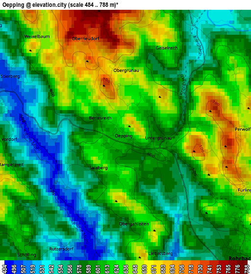
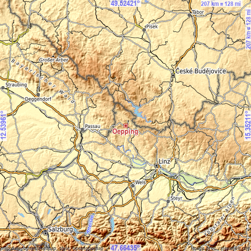
| \ | Map #1 | Topo.Map |
| Scale [m] | 484..788 m | × |
| Scale [ft] | 1588..2585 ft | × |
| Average | 606.1 m = 1989 ft | × |
| Width | 6.46 km = 4 mi | 206.8 km = 128.5 mi |
| Height | 6.46 km = 4 mi | 206.8 km = 128.5 mi |
| ↑Max Latitude | 48.631892° | 49.52421° |
| Latitude at center | 48.60284° | 48.60284° |
| ↓Min Latitude | 48.573772° | 47.66435° |
| ← Min Longitude | 13.901915° | 12.53961° |
| Longitude center | 13.94586° | 13.94586° |
| →Max Longitude | 13.989805° | 15.35211° |
Nearby cities:
Cities around Oepping sort by population:
• Rohrbach in Oberösterreich elevation 596 m
4.6 km,  136°
136°
• Aigen im Mühlkreis 601 m
5.1 km,  21°
21°
• Haslach an der Mühl 534 m
7.5 km,  113°
113°
• Lembach im Mühlkreis 549 m
12.5 km,  197°
197°
• Altenfelden 601 m
13.2 km,  172°
172°
• Ulrichsberg 630 m
8.4 km,  342°
342°
• Sarleinsbach 569 m
7.1 km,  205°
205°
• Klaffer am Hochficht 632 m
11.3 km, 335°
• Nebelberg 694 m
7.9 km,  291°
291°
• Arnreit 604 m
9.4 km,  157°
157°
• Atzesberg 674 m
9 km,  218°
218°
• Afiesl 843 m
13.6 km,  99°
99°
Multilingual:
 En español:
Oepping elevación 624 m.
 En France:
Oepping élévation 624 m.


Sources and notes:
- [note 1] Map square and city borders are not equal. Map elevation data is calculated only from area inside that square.
- [src 1] Elevation data from geonames database provided with same terms of usage.
- [src 2] The elevation map of Oepping is generated using elevation data from NASA's 3 arcsec (90m) resolution SRTM data.
- [src 3] Base (background) map © OpenStreetMap contributors tiles are generated by Geofabrik and OpenTopoMap.
Copyright & License:
This Oepping Elevation Map is licensed under CC BY-SA. You may reuse any part from this page, if you give a proper credit by linking to this URL:
 More info on terms of use page.