Ahorn elevation
Ahorn (Upper Austria, Politischer Bezirk Rohrbach), Austria elevation is 832 meters and Ahorn elevation in feet is 2730 ft above sea level [src 1]. Ahorn is a seat of a third-order administrative division (feature code) with elevation that is 323 meters (1060 ft) bigger than average city elevation in Austria.
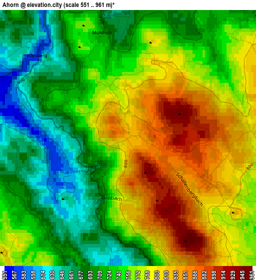
Below is the Elevation map of Ahorn, which displays elevation range with different colors. Scale of the first map is from 551 to 961 m (1808 to 3153 ft) with average elevation of 751.8 meters (=2467 ft) [note 1]
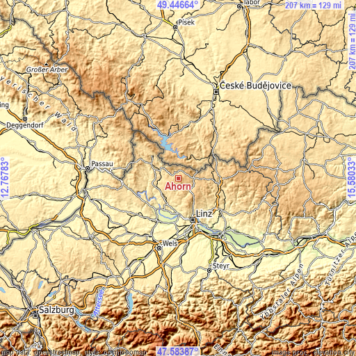
These maps also provides idea of topography and contour of this city, they are displayed at different zoom levels. More info about maps, scale and edge coordinates you can find below images.
| \ | Map #1 | Topo.Map |
| Scale [m] | 551..961 m | × |
| Scale [ft] | 1808..3153 ft | × |
| Average | 751.8 m = 2467 ft | × |
| Width | 6.47 km = 4 mi | 207.1 km = 128.7 mi |
| Height | 6.47 km = 4 mi | 207.1 km = 128.7 mi |
| ↑Max Latitude | 48.552917° | 49.44664° |
| Latitude at center | 48.52382° | 48.52382° |
| ↓Min Latitude | 48.494706° | 47.58387° |
| ← Min Longitude | 14.130135° | 12.76783° |
| Longitude center | 14.17408° | 14.17408° |
| →Max Longitude | 14.218025° | 15.58033° |
Nearby cities:
Cities around Ahorn sort by population:
• Burgfried elevation 744 m
9 km,  92°
92°
• Haslach an der Mühl 534 m
11.4 km,  300°
300°
• Hellmonsödt 819 m
13.7 km,  137°
137°
• Oberneukirchen 768 m
7.6 km,  151°
151°
• Schenkenfelden 737 m
14 km,  99°
99°
• Zwettl an der Rodl 617 m
9.7 km,  132°
132°
• Kirchschlag bei Linz 893 m
14.6 km, 148°
• Herzogsdorf 584 m
11.4 km,  203°
203°
• Bad Leonfelden 746 m
8.9 km, 92°
• Arnreit 604 m
13.2 km,  270°
270°
• Sonnberg im Mühlkreis 824 m
12.3 km,  124°
124°
• Afiesl 843 m
7.3 km,  332°
332°
Multilingual:
 En español:
Ahorn elevación 832 m.
 En France:
Ahorn élévation 832 m.


Sources and notes:
- [note 1] Map square and city borders are not equal. Map elevation data is calculated only from area inside that square.
- [src 1] Elevation data from geonames database provided with same terms of usage.
- [src 2] The elevation map of Ahorn is generated using elevation data from NASA's 3 arcsec (90m) resolution SRTM data.
- [src 3] Base (background) map © OpenStreetMap contributors tiles are generated by Geofabrik and OpenTopoMap.
Copyright & License:
This Ahorn Elevation Map is licensed under CC BY-SA. You may reuse any part from this page, if you give a proper credit by linking to this URL:
 More info on terms of use page.