Bretstein elevation
Bretstein (Styria, Politischer Bezirk Murtal), Austria elevation is 1024 meters and Bretstein elevation in feet is 3360 ft above sea level [src 1]. Bretstein is a seat of a third-order administrative division (feature code) with elevation that is 515 meters (1690 ft) bigger than average city elevation in Austria.
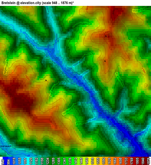
Below is the Elevation map of Bretstein, which displays elevation range with different colors. Scale of the first map is from 948 to 1876 m (3110 to 6155 ft) with average elevation of 1371.6 meters (=4500 ft) [note 1]
These maps also provides idea of topography and contour of this city, they are displayed at different zoom levels. More info about maps, scale and edge coordinates you can find below images.
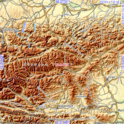
| \ | Map #1 | Topo.Map |
| Scale [m] | 948..1876 m | × |
| Scale [ft] | 3110..6155 ft | × |
| Average | 1371.6 m = 4500 ft | × |
| Width | 6.62 km = 4.1 mi | 211.9 km = 131.7 mi |
| Height | 6.62 km = 4.1 mi | 211.9 km = 131.7 mi |
| ↑Max Latitude | 47.363105° | 48.2778° |
| Latitude at center | 47.33333° | 47.33333° |
| ↓Min Latitude | 47.303538° | 46.37166° |
| ← Min Longitude | 14.372725° | 13.01042° |
| Longitude center | 14.41667° | 14.41667° |
| →Max Longitude | 14.460615° | 15.82292° |
Nearby cities:
Cities around Bretstein sort by population:
• Trieben elevation 683 m
17.8 km,  17°
17°
• Pöls 791 m
18.1 km,  135°
135°
• Scheifling 766 m
20.3 km,  180°
180°
• Oberzeiring 937 m
10.5 km,  151°
151°
• Pusterwald 1073 m
4.3 km,  225°
225°
• Oberwölz Stadt 825 m
17.8 km,  214°
214°
• Sankt Georgen ob Judenburg 734 m
15.3 km,  156°
156°
• Hohentauern 1274 m
12.2 km, 24°
• Oppenberg 1042 m
20.1 km,  325°
325°
• Gaal 898 m
20.3 km,  109°
109°
• Oberkurzheim 863 m
16.8 km,  131°
131°
• Sankt Johann am Tauern 1085 m
4.2 km,  63°
63°
Multilingual:
 En español:
Bretstein elevación 1024 m.
 En France:
Bretstein élévation 1024 m.
 Auf Deutsch:
Bretstein höhe über dem Meeresspiegel ist 1024 m.

Sources and notes:
- [note 1] Map square and city borders are not equal. Map elevation data is calculated only from area inside that square.
- [src 1] Elevation data from geonames database provided with same terms of usage.
- [src 2] The elevation map of Bretstein is generated using elevation data from NASA's 3 arcsec (90m) resolution SRTM data.
- [src 3] Base (background) map © OpenStreetMap contributors tiles are generated by Geofabrik and OpenTopoMap.
Copyright & License:
This Bretstein Elevation Map is licensed under CC BY-SA. You may reuse any part from this page, if you give a proper credit by linking to this URL:
 More info on terms of use page.