Gaal elevation
Gaal (Styria, Politischer Bezirk Murtal), Austria elevation is 898 meters and Gaal elevation in feet is 2946 ft above sea level [src 1]. Gaal is a seat of a third-order administrative division (feature code) with elevation that is 389 meters (1276 ft) bigger than average city elevation in Austria.
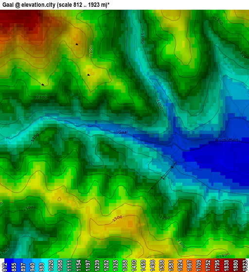
Below is the Elevation map of Gaal, which displays elevation range with different colors. Scale of the first map is from 812 to 1923 m (2664 to 6309 ft) with average elevation of 1222 meters (=4009 ft) [note 1]
These maps also provides idea of topography and contour of this city, they are displayed at different zoom levels. More info about maps, scale and edge coordinates you can find below images.
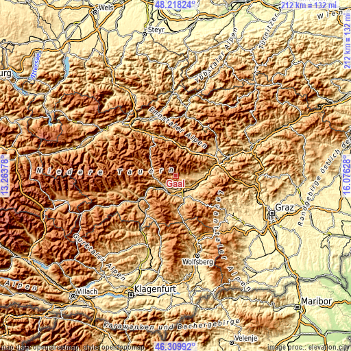
| \ | Map #1 | Topo.Map |
| Scale [m] | 812..1923 m | × |
| Scale [ft] | 2664..6309 ft | × |
| Average | 1222 m = 4009 ft | × |
| Width | 6.63 km = 4.1 mi | 212.2 km = 131.9 mi |
| Height | 6.63 km = 4.1 mi | 212.2 km = 131.9 mi |
| ↑Max Latitude | 47.302489° | 48.21824° |
| Latitude at center | 47.27268° | 47.27268° |
| ↓Min Latitude | 47.242854° | 46.30992° |
| ← Min Longitude | 14.626085° | 13.26378° |
| Longitude center | 14.67003° | 14.67003° |
| →Max Longitude | 14.713975° | 16.07628° |
Nearby cities:
Cities around Gaal sort by population:
• Judenburg elevation 754 m
11.8 km,  181°
181°
• Zeltweg 652 m
11.6 km,  148°
148°
• Spielberg bei Knittelfeld 707 m
10.6 km,  126°
126°
• Fohnsdorf 757 m
8.1 km,  172°
172°
• Dietersdorf 726 m
8.1 km, 181°
• Pöls 791 m
9 km,  226°
226°
• Farrach 674 m
11 km, 154°
• Hetzendorf 729 m
10 km, 174°
• Seckau 848 m
8.6 km,  94°
94°
• Sankt Peter ob Judenburg 792 m
11.7 km,  212°
212°
• Flatschach 677 m
8.7 km,  135°
135°
• Oberkurzheim 863 m
7.9 km,  236°
236°
Multilingual:
 En español:
Gaal elevación 898 m.
 En France:
Gaal élévation 898 m.


Sources and notes:
- [note 1] Map square and city borders are not equal. Map elevation data is calculated only from area inside that square.
- [src 1] Elevation data from geonames database provided with same terms of usage.
- [src 2] The elevation map of Gaal is generated using elevation data from NASA's 3 arcsec (90m) resolution SRTM data.
- [src 3] Base (background) map © OpenStreetMap contributors tiles are generated by Geofabrik and OpenTopoMap.
Copyright & License:
This Gaal Elevation Map is licensed under CC BY-SA. You may reuse any part from this page, if you give a proper credit by linking to this URL:
 More info on terms of use page.