Seckau elevation
Seckau (Styria, Politischer Bezirk Murtal), Austria elevation is 848 meters and Seckau elevation in feet is 2782 ft above sea level [src 1]. Seckau is a seat of a third-order administrative division (feature code) with elevation that is 339 meters (1112 ft) bigger than average city elevation in Austria.
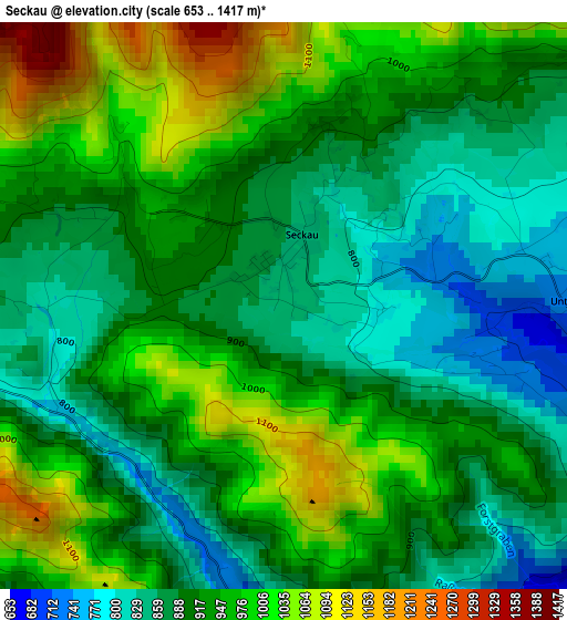
Below is the Elevation map of Seckau, which displays elevation range with different colors. Scale of the first map is from 653 to 1417 m (2142 to 4649 ft) with average elevation of 925.3 meters (=3036 ft) [note 1]
These maps also provides idea of topography and contour of this city, they are displayed at different zoom levels. More info about maps, scale and edge coordinates you can find below images.
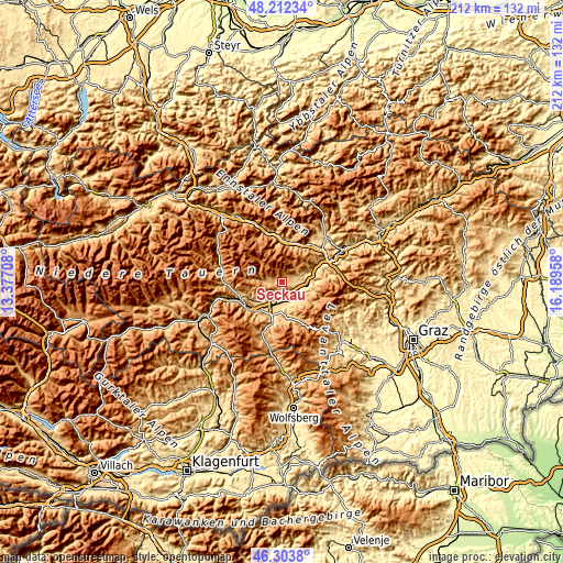
| \ | Map #1 | Topo.Map |
| Scale [m] | 653..1417 m | × |
| Scale [ft] | 2142..4649 ft | × |
| Average | 925.3 m = 3036 ft | × |
| Width | 6.63 km = 4.1 mi | 212.2 km = 131.9 mi |
| Height | 6.63 km = 4.1 mi | 212.2 km = 131.9 mi |
| ↑Max Latitude | 47.296482° | 48.21234° |
| Latitude at center | 47.26667° | 47.26667° |
| ↓Min Latitude | 47.236841° | 46.3038° |
| ← Min Longitude | 14.739385° | 13.37708° |
| Longitude center | 14.78333° | 14.78333° |
| →Max Longitude | 14.827275° | 16.18958° |
Nearby cities:
Cities around Seckau sort by population:
• Knittelfeld elevation 654 m
6.1 km,  155°
155°
• Zeltweg 652 m
9.6 km,  195°
195°
• Spielberg bei Knittelfeld 707 m
5.6 km,  180°
180°
• Großlobming 646 m
9.4 km,  172°
172°
• Sankt Margarethen bei Knittelfeld 833 m
8.4 km,  131°
131°
• Kobenz 640 m
5.4 km,  110°
110°
• Feistritz bei Knittelfeld 638 m
8.3 km,  88°
88°
• Sankt Lorenzen bei Knittelfeld 603 m
8.6 km,  101°
101°
• Sankt Marein bei Knittelfeld 705 m
5.9 km,  82°
82°
• Apfelberg 623 m
8.3 km,  153°
153°
• Flatschach 677 m
6.1 km, 204°
• Gaal 898 m
8.6 km,  274°
274°
Multilingual:
 En español:
Seckau elevación 848 m.
 En France:
Seckau élévation 848 m.


Sources and notes:
- [note 1] Map square and city borders are not equal. Map elevation data is calculated only from area inside that square.
- [src 1] Elevation data from geonames database provided with same terms of usage.
- [src 2] The elevation map of Seckau is generated using elevation data from NASA's 3 arcsec (90m) resolution SRTM data.
- [src 3] Base (background) map © OpenStreetMap contributors tiles are generated by Geofabrik and OpenTopoMap.
Copyright & License:
This Seckau Elevation Map is licensed under CC BY-SA. You may reuse any part from this page, if you give a proper credit by linking to this URL:
 More info on terms of use page.