Flatschach elevation
Flatschach (Styria, Politischer Bezirk Murtal), Austria elevation is 677 meters and Flatschach elevation in feet is 2221 ft above sea level [src 1]. Flatschach is a seat of a third-order administrative division (feature code) with elevation that is 168 meters (551 ft) bigger than average city elevation in Austria.
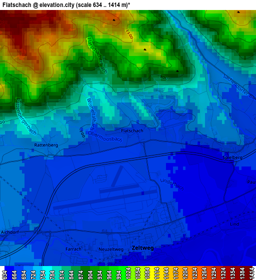
Below is the Elevation map of Flatschach, which displays elevation range with different colors. Scale of the first map is from 634 to 1414 m (2080 to 4639 ft) with average elevation of 784.4 meters (=2573 ft) [note 1]
These maps also provides idea of topography and contour of this city, they are displayed at different zoom levels. More info about maps, scale and edge coordinates you can find below images.
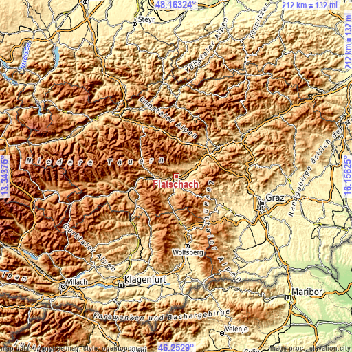
| \ | Map #1 | Topo.Map |
| Scale [m] | 634..1414 m | × |
| Scale [ft] | 2080..4639 ft | × |
| Average | 784.4 m = 2573 ft | × |
| Width | 6.64 km = 4.1 mi | 212.4 km = 132 mi |
| Height | 6.64 km = 4.1 mi | 212.4 km = 132 mi |
| ↑Max Latitude | 47.24651° | 48.16324° |
| Latitude at center | 47.21667° | 47.21667° |
| ↓Min Latitude | 47.186813° | 46.2529° |
| ← Min Longitude | 14.706055° | 13.34375° |
| Longitude center | 14.75° | 14.75° |
| →Max Longitude | 14.793945° | 16.15625° |
Nearby cities:
Cities around Flatschach sort by population:
• Knittelfeld elevation 654 m
5 km,  90°
90°
• Zeltweg 652 m
3.7 km,  180°
180°
• Spielberg bei Knittelfeld 707 m
2.5 km, 90°
• Fohnsdorf 757 m
5.4 km,  249°
249°
• Dietersdorf 726 m
6.6 km, 253°
• Weißkirchen in Steiermark 690 m
7.5 km,  189°
189°
• Großlobming 646 m
5.3 km,  134°
134°
• Farrach 674 m
3.9 km,  198°
198°
• Hetzendorf 729 m
6.3 km,  233°
233°
• Kobenz 640 m
8.4 km,  63°
63°
• Seckau 848 m
6.1 km,  24°
24°
• Apfelberg 623 m
6.6 km,  106°
106°
Multilingual:
 En español:
Flatschach elevación 677 m.
 En France:
Flatschach élévation 677 m.
 Auf Deutsch:
Flatschach höhe über dem Meeresspiegel ist 677 m.

Sources and notes:
- [note 1] Map square and city borders are not equal. Map elevation data is calculated only from area inside that square.
- [src 1] Elevation data from geonames database provided with same terms of usage.
- [src 2] The elevation map of Flatschach is generated using elevation data from NASA's 3 arcsec (90m) resolution SRTM data.
- [src 3] Base (background) map © OpenStreetMap contributors tiles are generated by Geofabrik and OpenTopoMap.
Copyright & License:
This Flatschach Elevation Map is licensed under CC BY-SA. You may reuse any part from this page, if you give a proper credit by linking to this URL:
 More info on terms of use page.