Dietach elevation
Dietach (Upper Austria, Politischer Bezirk Steyr-Land), Austria elevation is 304 meters and Dietach elevation in feet is 997 ft above sea level [src 1]. Dietach is a populated place (feature code) with elevation that is 205 meters (673 ft) smaller than average city elevation in Austria.
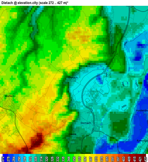
Below is the Elevation map of Dietach, which displays elevation range with different colors. Scale of the first map is from 272 to 427 m (892 to 1401 ft) with average elevation of 332.6 meters (=1091 ft) [note 1]
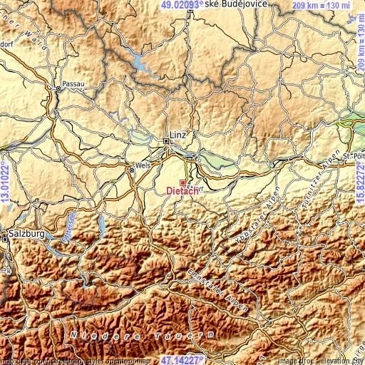
These maps also provides idea of topography and contour of this city, they are displayed at different zoom levels. More info about maps, scale and edge coordinates you can find below images.
| \ | Map #1 | Topo.Map |
| Scale [m] | 272..427 m | × |
| Scale [ft] | 892..1401 ft | × |
| Average | 332.6 m = 1091 ft | × |
| Width | 6.53 km = 4.1 mi | 208.9 km = 129.8 mi |
| Height | 6.53 km = 4.1 mi | 208.9 km = 129.8 mi |
| ↑Max Latitude | 48.119525° | 49.02093° |
| Latitude at center | 48.09018° | 48.09018° |
| ↓Min Latitude | 48.060818° | 47.14227° |
| ← Min Longitude | 14.372525° | 13.01022° |
| Longitude center | 14.41647° | 14.41647° |
| →Max Longitude | 14.460415° | 15.82272° |
Nearby cities:
Cities around Dietach sort by population:
• Steyr elevation 285 m
5.3 km,  176°
176°
• Neuzeug 334 m
7.6 km,  234°
234°
• Sierning 359 m
9.5 km,  236°
236°
• Haidershofen 291 m
3.7 km,  115°
115°
• Wolfern 361 m
3.4 km,  256°
256°
• Garsten 294 m
7.6 km,  185°
185°
• Ernsthofen 275 m
6.4 km,  47°
47°
• Penz 445 m
8 km,  141°
141°
• Kronstorf 271 m
6.8 km,  30°
30°
• Sankt Ulrich bei Steyr 419 m
7.8 km,  168°
168°
• Dietachdorf 302 m
1.2 km,  128°
128°
• Hofkirchen im Traunkreis 334 m
6.6 km,  333°
333°
Multilingual:
 En español:
Dietach elevación 304 m.
 En France:
Dietach élévation 304 m.


Sources and notes:
- [note 1] Map square and city borders are not equal. Map elevation data is calculated only from area inside that square.
- [src 1] Elevation data from geonames database provided with same terms of usage.
- [src 2] The elevation map of Dietach is generated using elevation data from NASA's 3 arcsec (90m) resolution SRTM data.
- [src 3] Base (background) map © OpenStreetMap contributors tiles are generated by Geofabrik and OpenTopoMap.
Copyright & License:
This Dietach Elevation Map is licensed under CC BY-SA. You may reuse any part from this page, if you give a proper credit by linking to this URL:
 More info on terms of use page.