Kronstorf elevation
Kronstorf (Upper Austria, Politischer Bezirk Linz-Land), Austria elevation is 271 meters and Kronstorf elevation in feet is 889 ft above sea level [src 1]. Kronstorf is a populated place (feature code) with elevation that is 238 meters (781 ft) smaller than average city elevation in Austria.
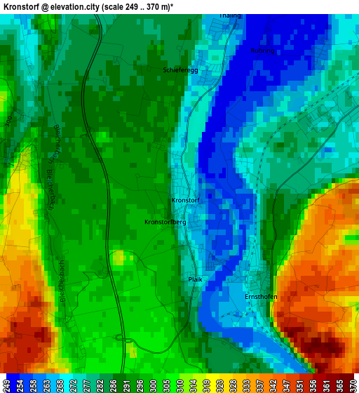
Below is the Elevation map of Kronstorf, which displays elevation range with different colors. Scale of the first map is from 249 to 370 m (817 to 1214 ft) with average elevation of 291.3 meters (=956 ft) [note 1]
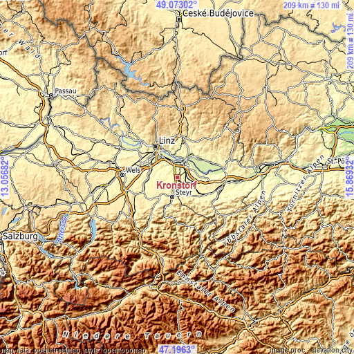
These maps also provides idea of topography and contour of this city, they are displayed at different zoom levels. More info about maps, scale and edge coordinates you can find below images.
| \ | Map #1 | Topo.Map |
| Scale [m] | 249..370 m | × |
| Scale [ft] | 817..1214 ft | × |
| Average | 291.3 m = 956 ft | × |
| Width | 6.52 km = 4.1 mi | 208.7 km = 129.7 mi |
| Height | 6.52 km = 4.1 mi | 208.7 km = 129.7 mi |
| ↑Max Latitude | 48.172555° | 49.07302° |
| Latitude at center | 48.14324° | 48.14324° |
| ↓Min Latitude | 48.113908° | 47.1963° |
| ← Min Longitude | 14.419125° | 13.05682° |
| Longitude center | 14.46307° | 14.46307° |
| →Max Longitude | 14.507015° | 15.86932° |
Nearby cities:
Cities around Kronstorf sort by population:
• Enns elevation 268 m
7.9 km,  7°
7°
• Sankt Valentin 269 m
4.8 km,  56°
56°
• Haidershofen 291 m
7.5 km,  180°
180°
• Asten 251 m
9.1 km,  338°
338°
• Ennsdorf 245 m
8.2 km,  21°
21°
• Haag 323 m
8.4 km,  113°
113°
• Ernsthofen 275 m
2 km,  140°
140°
• Fisching 247 m
9.2 km, 343°
• Dietach 304 m
6.8 km,  210°
210°
• Dietachdorf 302 m
7.1 km,  201°
201°
• Hofkirchen im Traunkreis 334 m
6.3 km,  269°
269°
• Niederneukirchen 333 m
9.4 km,  282°
282°
Multilingual:
 En español:
Kronstorf elevación 271 m.
 En France:
Kronstorf élévation 271 m.
 Auf Deutsch:
Kronstorf höhe über dem Meeresspiegel ist 271 m.
 На русском:
Кроншторф, Кронсторф высота над уровнем моря 271 м
Sources and notes:
- [note 1] Map square and city borders are not equal. Map elevation data is calculated only from area inside that square.
- [src 1] Elevation data from geonames database provided with same terms of usage.
- [src 2] The elevation map of Kronstorf is generated using elevation data from NASA's 3 arcsec (90m) resolution SRTM data.
- [src 3] Base (background) map © OpenStreetMap contributors tiles are generated by Geofabrik and OpenTopoMap.
Copyright & License:
This Kronstorf Elevation Map is licensed under CC BY-SA. You may reuse any part from this page, if you give a proper credit by linking to this URL:
 More info on terms of use page.