Steyr elevation
Steyr (Upper Austria, Steyr Stadt), Austria elevation is 285 meters and Steyr elevation in feet is 935 ft above sea level [src 1]. Steyr is a seat of a third-order administrative division (feature code) with elevation that is 224 meters (735 ft) smaller than average city elevation in Austria.
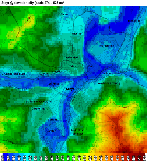
Below is the Elevation map of Steyr, which displays elevation range with different colors. Scale of the first map is from 274 to 523 m (899 to 1716 ft) with average elevation of 347.8 meters (=1141 ft) [note 1]
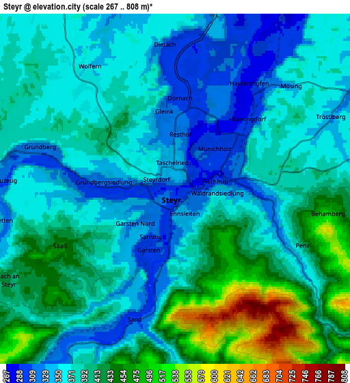
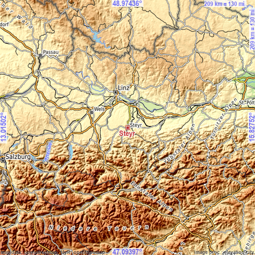
These maps also provides idea of topography and contour of this city, they are displayed at different zoom levels. More info about maps, scale and edge coordinates you can find below images.
| \ | Map #1 | Map #2 | Topo.Map |
| Scale [m] | 274..523 m | 267..808 m | × |
| Scale [ft] | 899..1716 ft | 876..2651 ft | × |
| Average | 347.8 m = 1141 ft | 389 m = 1276 ft | × |
| Width | 6.53 km = 4.1 mi | 13.07 km = 8.1 mi | 209.1 km = 129.9 mi |
| Height | 6.53 km = 4.1 mi | 13.07 km = 8.1 mi | 209.1 km = 129.9 mi |
| ↑Max Latitude | 48.072112° | 48.101468° | 48.97436° |
| Latitude at center | 48.04274° | 48.04274° | 48.04274° |
| ↓Min Latitude | 48.013351° | 47.983945° | 47.09397° |
| ← Min Longitude | 14.377325° | 14.333379° | 13.01502° |
| Longitude center | 14.42127° | 14.42127° | 14.42127° |
| →Max Longitude | 14.465215° | 14.509161° | 15.82752° |
Nearby cities:
Cities around Steyr sort by population:
• Neuzeug elevation 334 m
6.6 km,  277°
277°
• Sierning 359 m
8.3 km,  270°
270°
• Haidershofen 291 m
4.7 km,  38°
38°
• Wolfern 361 m
5.8 km,  320°
320°
• Garsten 294 m
2.5 km,  204°
204°
• Penz 445 m
4.7 km,  102°
102°
• Aschach an der Steyr 426 m
7.2 km,  242°
242°
• Dietach 304 m
5.3 km,  356°
356°
• Sankt Ulrich bei Steyr 419 m
2.7 km,  154°
154°
• Dietachdorf 302 m
4.6 km,  6°
6°
• Laussa 492 m
10.5 km,  168°
168°
• Behamberg 348 m
5.4 km,  122°
122°
Multilingual:
 En español:
Steyr elevación 285 m.
 En France:
Steyr élévation 285 m.


Sources and notes:
- [note 1] Map square and city borders are not equal. Map elevation data is calculated only from area inside that square.
- [src 1] Elevation data from geonames database provided with same terms of usage.
- [src 2] The elevation map of Steyr is generated using elevation data from NASA's 3 arcsec (90m) resolution SRTM data.
- [src 3] Base (background) map © OpenStreetMap contributors tiles are generated by Geofabrik and OpenTopoMap.
Copyright & License:
This Steyr Elevation Map is licensed under CC BY-SA. You may reuse any part from this page, if you give a proper credit by linking to this URL:
 More info on terms of use page.