Floridsdorf elevation
Floridsdorf (Vienna, Wien Stadt), Austria elevation is 159 meters and Floridsdorf elevation in feet is 522 ft above sea level [src 1]. Floridsdorf is a section of populated place (feature code) with elevation that is 350 meters (1148 ft) smaller than average city elevation in Austria.
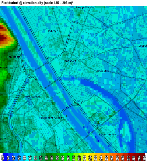
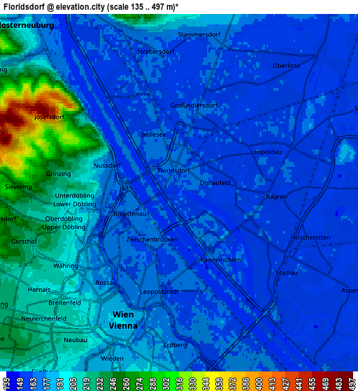
Below is the Elevation map of Floridsdorf, which displays elevation range with different colors. Scale of the first map is from 135 to 293 m (443 to 961 ft) with average elevation of 163.4 meters (=536 ft) [note 1]
These maps also provides idea of topography and contour of this city, they are displayed at different zoom levels. More info about maps, scale and edge coordinates you can find below images.
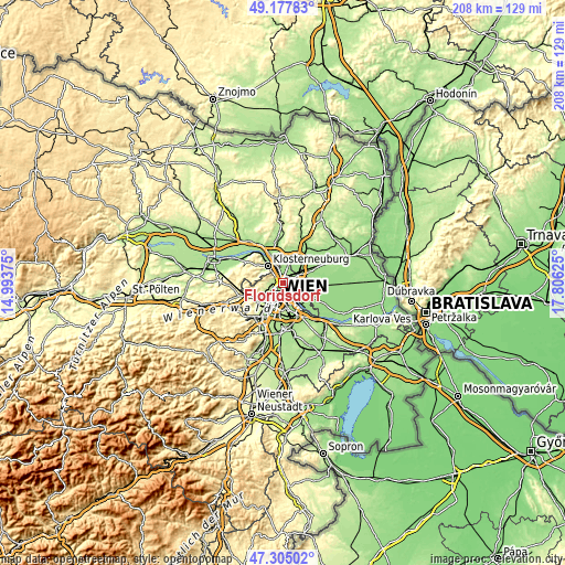
| \ | Map #1 | Map #2 | Topo.Map |
| Scale [m] | 135..293 m | 135..497 m | × |
| Scale [ft] | 443..961 ft | 443..1631 ft | × |
| Average | 163.4 m = 536 ft | 182.6 m = 599 ft | × |
| Width | 6.51 km = 4 mi | 13.01 km = 8.1 mi | 208.2 km = 129.4 mi |
| Height | 6.51 km = 4 mi | 13.01 km = 8.1 mi | 208.2 km = 129.4 mi |
| ↑Max Latitude | 48.279254° | 48.308491° | 49.17783° |
| Latitude at center | 48.25° | 48.25° | 48.25° |
| ↓Min Latitude | 48.220729° | 48.191442° | 47.30502° |
| ← Min Longitude | 16.356055° | 16.312109° | 14.99375° |
| Longitude center | 16.4° | 16.4° | 16.4° |
| →Max Longitude | 16.443945° | 16.487891° | 17.80625° |
Nearby cities:
Cities around Floridsdorf sort by population:
• Vienna elevation 193 m
5.1 km,  204°
204°
• Favoriten 236 m
10 km,  187°
187°
• Donaustadt 149 m
4.8 km,  112°
112°
• Ottakring 247 m
8.3 km,  243°
243°
• Simmering 163 m
7.8 km,  161°
161°
• Hernals 339 m
10 km,  259°
259°
• Innere Stadt 190 m
5 km, 204°
• Klosterneuburg 192 m
8.3 km,  317°
317°
• Gerasdorf bei Wien 158 m
7 km,  45°
45°
• Langenzersdorf 161 m
6.7 km,  334°
334°
• Weidling 198 m
8.2 km,  303°
303°
• Hagenbrunn 229 m
9.3 km,  0°
0°
Multilingual:
 En español:
Floridsdorf elevación 159 m.
 En France:
Floridsdorf élévation 159 m.
 Auf Deutsch:
Floridsdorf höhe über dem Meeresspiegel ist 159 m.

Sources and notes:
- [note 1] Map square and city borders are not equal. Map elevation data is calculated only from area inside that square.
- [src 1] Elevation data from geonames database provided with same terms of usage.
- [src 2] The elevation map of Floridsdorf is generated using elevation data from NASA's 3 arcsec (90m) resolution SRTM data.
- [src 3] Base (background) map © OpenStreetMap contributors tiles are generated by Geofabrik and OpenTopoMap.
Copyright & License:
This Floridsdorf Elevation Map is licensed under CC BY-SA. You may reuse any part from this page, if you give a proper credit by linking to this URL:
 More info on terms of use page.