Klosterneuburg elevation
Klosterneuburg (Lower Austria, Politischer Bezirk Tulln), Austria elevation is 192 meters and Klosterneuburg elevation in feet is 630 ft above sea level [src 1]. Klosterneuburg is a seat of a third-order administrative division (feature code) with elevation that is 317 meters (1040 ft) smaller than average city elevation in Austria.
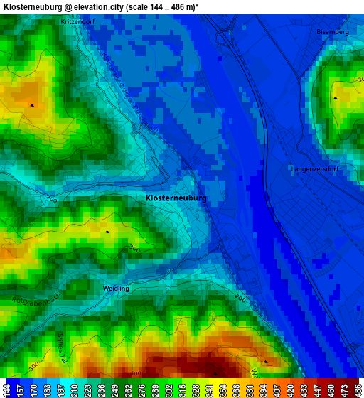
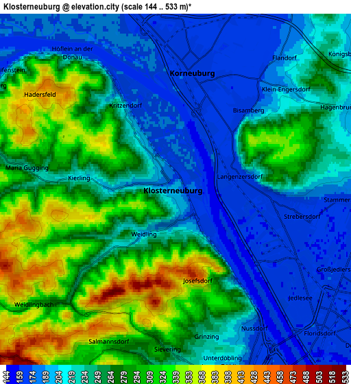
Below is the Elevation map of Klosterneuburg, which displays elevation range with different colors. Scale of the first map is from 144 to 486 m (472 to 1594 ft) with average elevation of 228.5 meters (=750 ft) [note 1]
These maps also provides idea of topography and contour of this city, they are displayed at different zoom levels. More info about maps, scale and edge coordinates you can find below images.
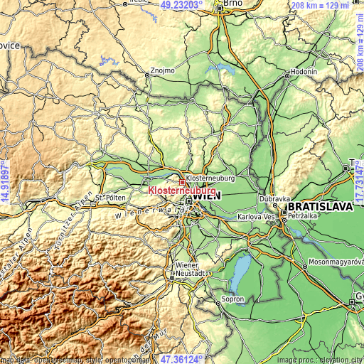
| \ | Map #1 | Map #2 | Topo.Map |
| Scale [m] | 144..486 m | 144..533 m | × |
| Scale [ft] | 472..1594 ft | 472..1749 ft | × |
| Average | 228.5 m = 750 ft | 248.8 m = 816 ft | × |
| Width | 6.5 km = 4 mi | 13 km = 8.1 mi | 208 km = 129.2 mi |
| Height | 6.5 km = 4 mi | 13 km = 8.1 mi | 208 km = 129.2 mi |
| ↑Max Latitude | 48.334432° | 48.363638° | 49.23203° |
| Latitude at center | 48.30521° | 48.30521° | 48.30521° |
| ↓Min Latitude | 48.275971° | 48.246715° | 47.36124° |
| ← Min Longitude | 16.281275° | 16.237329° | 14.91897° |
| Longitude center | 16.32522° | 16.32522° | 16.32522° |
| →Max Longitude | 16.369165° | 16.413111° | 17.73147° |
Nearby cities:
Cities around Klosterneuburg sort by population:
• Floridsdorf elevation 159 m
8.3 km,  137°
137°
• Korneuburg 164 m
5 km,  6°
6°
• Langenzersdorf 161 m
2.7 km,  92°
92°
• Bisamberg 164 m
3.6 km,  30°
30°
• Kierling 212 m
3.7 km,  278°
278°
• Weidling 198 m
2 km,  217°
217°
• Leobendorf 234 m
8.7 km,  355°
355°
• Kritzendorf 205 m
3.3 km,  325°
325°
• Hagenbrunn 229 m
6.4 km,  60°
60°
• Sankt Andrä vor dem Hagenthale 192 m
8.9 km, 282°
• Stetten 181 m
8.1 km, 32°
• Gugging 246 m
5.8 km, 279°
Multilingual:
 En español:
Klosterneuburg elevación 192 m.
 En France:
Klosterneuburg élévation 192 m.
 Auf Deutsch:
Klosterneuburg höhe über dem Meeresspiegel ist 192 m.

Sources and notes:
- [note 1] Map square and city borders are not equal. Map elevation data is calculated only from area inside that square.
- [src 1] Elevation data from geonames database provided with same terms of usage.
- [src 2] The elevation map of Klosterneuburg is generated using elevation data from NASA's 3 arcsec (90m) resolution SRTM data.
- [src 3] Base (background) map © OpenStreetMap contributors tiles are generated by Geofabrik and OpenTopoMap.
Copyright & License:
This Klosterneuburg Elevation Map is licensed under CC BY-SA. You may reuse any part from this page, if you give a proper credit by linking to this URL:
 More info on terms of use page.