Galtür elevation
Galtür (Tyrol, Politischer Bezirk Landeck), Austria elevation is 1592 meters and Galtür elevation in feet is 5223 ft above sea level [src 1]. Galtür is a seat of a third-order administrative division (feature code) with elevation that is 1083 meters (3553 ft) bigger than average city elevation in Austria.
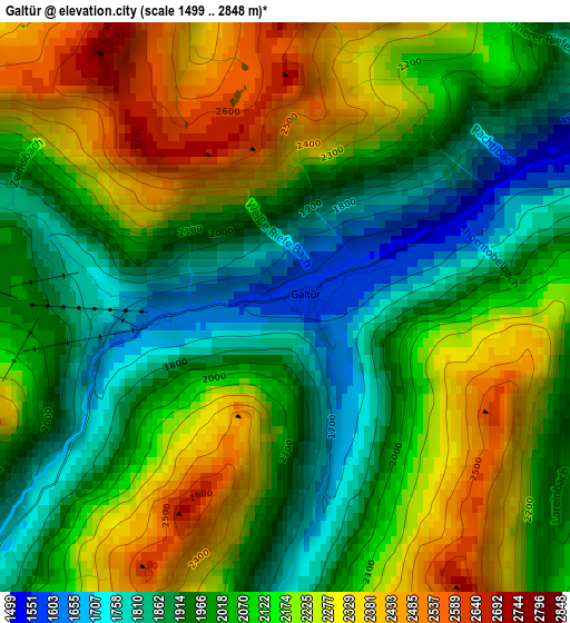
Below is the Elevation map of Galtür, which displays elevation range with different colors. Scale of the first map is from 1499 to 2848 m (4918 to 9344 ft) with average elevation of 2090.9 meters (=6860 ft) [note 1]
These maps also provides idea of topography and contour of this city, they are displayed at different zoom levels. More info about maps, scale and edge coordinates you can find below images.
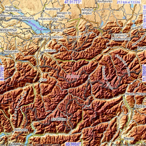
| \ | Map #1 | Topo.Map |
| Scale [m] | 1499..2848 m | × |
| Scale [ft] | 4918..9344 ft | × |
| Average | 2090.9 m = 6860 ft | × |
| Width | 6.67 km = 4.1 mi | 213.4 km = 132.6 mi |
| Height | 6.67 km = 4.1 mi | 213.4 km = 132.6 mi |
| ↑Max Latitude | 46.996651° | 47.91773° |
| Latitude at center | 46.96667° | 46.96667° |
| ↓Min Latitude | 46.936672° | 45.9984° |
| ← Min Longitude | 10.139385° | 8.77708° |
| Longitude center | 10.18333° | 10.18333° |
| →Max Longitude | 10.227275° | 11.58958° |
Nearby cities:
Cities around Galtür sort by population:
• Schruns elevation 689 m
23.1 km,  298°
298°
• Tschagguns 667 m
25.1 km, 301°
• Kappl 1321 m
18.8 km,  53°
53°
• St Anton am Arlberg 1307 m
18.9 km,  18°
18°
• Sankt Gallenkirch 879 m
17 km,  290°
290°
• See 1036 m
25.1 km,  58°
58°
• Ischgl 1378 m
9.7 km, 58°
• Pettneu 1193 m
23.1 km,  30°
30°
• Gaschurn 969 m
12 km,  280°
280°
• Dalaas 873 m
22.8 km,  320°
320°
• Silbertal 886 m
20.7 km,  312°
312°
• Klösterle 1124 m
20 km,  337°
337°
Multilingual:
 En español:
Galtür elevación 1592 m.
 En France:
Galtür élévation 1592 m.


Sources and notes:
- [note 1] Map square and city borders are not equal. Map elevation data is calculated only from area inside that square.
- [src 1] Elevation data from geonames database provided with same terms of usage.
- [src 2] The elevation map of Galtür is generated using elevation data from NASA's 3 arcsec (90m) resolution SRTM data.
- [src 3] Base (background) map © OpenStreetMap contributors tiles are generated by Geofabrik and OpenTopoMap.
Copyright & License:
This Galtür Elevation Map is licensed under CC BY-SA. You may reuse any part from this page, if you give a proper credit by linking to this URL:
 More info on terms of use page.