Göllersdorf elevation
Göllersdorf (Lower Austria, Politischer Bezirk Hollabrunn), Austria elevation is 200 meters and Göllersdorf elevation in feet is 656 ft above sea level [src 1]. Göllersdorf is a seat of a third-order administrative division (feature code) with elevation that is 309 meters (1014 ft) smaller than average city elevation in Austria.
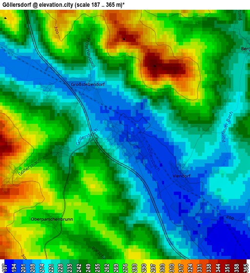
Below is the Elevation map of Göllersdorf, which displays elevation range with different colors. Scale of the first map is from 187 to 365 m (614 to 1198 ft) with average elevation of 248.2 meters (=814 ft) [note 1]
These maps also provides idea of topography and contour of this city, they are displayed at different zoom levels. More info about maps, scale and edge coordinates you can find below images.
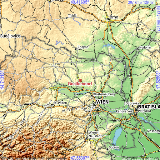
| \ | Map #1 | Topo.Map |
| Scale [m] | 187..365 m | × |
| Scale [ft] | 614..1198 ft | × |
| Average | 248.2 m = 814 ft | × |
| Width | 6.48 km = 4 mi | 207.2 km = 128.7 mi |
| Height | 6.48 km = 4 mi | 207.2 km = 128.7 mi |
| ↑Max Latitude | 48.522684° | 49.41695° |
| Latitude at center | 48.49357° | 48.49357° |
| ↓Min Latitude | 48.464439° | 47.55307° |
| ← Min Longitude | 16.075485° | 14.71318° |
| Longitude center | 16.11943° | 16.11943° |
| →Max Longitude | 16.163375° | 17.52568° |
Nearby cities:
Cities around Göllersdorf sort by population:
• Stockerau elevation 171 m
14.2 km,  149°
149°
• Hollabrunn 257 m
6.8 km,  337°
337°
• Absdorf 181 m
14.7 km,  224°
224°
• Großweikersdorf 204 m
10.4 km,  256°
256°
• Ziersdorf 235 m
14.8 km,  286°
286°
• Sierndorf 190 m
7.9 km, 153°
• Hausleiten 171 m
12.3 km,  186°
186°
• Wullersdorf 230 m
15 km,  354°
354°
• Leitzersdorf 223 m
12.4 km,  131°
131°
• Niederhollabrunn 319 m
14.9 km,  116°
116°
• Großmugl 216 m
8.2 km,  85°
85°
• Stetteldorf am Wagram 208 m
12.1 km, 218°
Multilingual:
 En español:
Göllersdorf elevación 200 m.
 En France:
Göllersdorf élévation 200 m.
 Auf Deutsch:
Göllersdorf höhe über dem Meeresspiegel ist 200 m.

Sources and notes:
- [note 1] Map square and city borders are not equal. Map elevation data is calculated only from area inside that square.
- [src 1] Elevation data from geonames database provided with same terms of usage.
- [src 2] The elevation map of Göllersdorf is generated using elevation data from NASA's 3 arcsec (90m) resolution SRTM data.
- [src 3] Base (background) map © OpenStreetMap contributors tiles are generated by Geofabrik and OpenTopoMap.
Copyright & License:
This Göllersdorf Elevation Map is licensed under CC BY-SA. You may reuse any part from this page, if you give a proper credit by linking to this URL:
 More info on terms of use page.