Absdorf elevation
Absdorf (Lower Austria, Politischer Bezirk Tulln), Austria elevation is 181 meters and Absdorf elevation in feet is 594 ft above sea level [src 1]. Absdorf is a seat of a third-order administrative division (feature code) with elevation that is 328 meters (1076 ft) smaller than average city elevation in Austria.
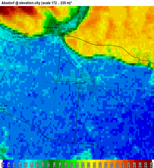
Below is the Elevation map of Absdorf, which displays elevation range with different colors. Scale of the first map is from 172 to 235 m (564 to 771 ft) with average elevation of 186.7 meters (=613 ft) [note 1]
These maps also provides idea of topography and contour of this city, they are displayed at different zoom levels. More info about maps, scale and edge coordinates you can find below images.
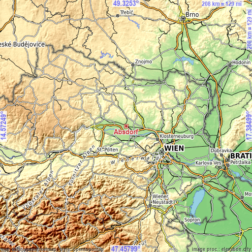
| \ | Map #1 | Topo.Map |
| Scale [m] | 172..235 m | × |
| Scale [ft] | 564..771 ft | × |
| Average | 186.7 m = 613 ft | × |
| Width | 6.49 km = 4 mi | 207.6 km = 129 mi |
| Height | 6.49 km = 4 mi | 207.6 km = 129 mi |
| ↑Max Latitude | 48.429378° | 49.3253° |
| Latitude at center | 48.40021° | 48.40021° |
| ↓Min Latitude | 48.371025° | 47.45799° |
| ← Min Longitude | 15.934795° | 14.57249° |
| Longitude center | 15.97874° | 15.97874° |
| →Max Longitude | 16.022685° | 17.38499° |
Nearby cities:
Cities around Absdorf sort by population:
• Tulln elevation 175 m
9.9 km,  143°
143°
• Großweikersdorf 204 m
7.9 km,  2°
2°
• Fels am Wagram 209 m
12.5 km,  287°
287°
• Erpersdorf 185 m
7.9 km,  215°
215°
• Hausleiten 171 m
9.1 km,  101°
101°
• Langenlebarn-Oberaigen 174 m
12.5 km,  128°
128°
• Langenrohr 179 m
10.9 km,  167°
167°
• Kirchberg am Wagram 187 m
7 km,  300°
300°
• Michelhausen 189 m
12.5 km,  193°
193°
• Zwentendorf 184 m
7.9 km, 219°
• Stetteldorf am Wagram 208 m
3.1 km,  73°
73°
• Großriedenthal 276 m
12.4 km,  318°
318°
Multilingual:
 En español:
Absdorf elevación 181 m.
 En France:
Absdorf élévation 181 m.


Sources and notes:
- [note 1] Map square and city borders are not equal. Map elevation data is calculated only from area inside that square.
- [src 1] Elevation data from geonames database provided with same terms of usage.
- [src 2] The elevation map of Absdorf is generated using elevation data from NASA's 3 arcsec (90m) resolution SRTM data.
- [src 3] Base (background) map © OpenStreetMap contributors tiles are generated by Geofabrik and OpenTopoMap.
Copyright & License:
This Absdorf Elevation Map is licensed under CC BY-SA. You may reuse any part from this page, if you give a proper credit by linking to this URL:
 More info on terms of use page.