Hintersee elevation
Hintersee (Salzburg, Politischer Bezirk Salzburg-Umgebung), Austria elevation is 972 meters and Hintersee elevation in feet is 3189 ft above sea level [src 1]. Hintersee is a seat of a third-order administrative division (feature code) with elevation that is 463 meters (1519 ft) bigger than average city elevation in Austria.
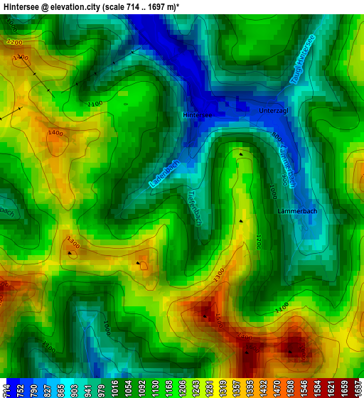
Below is the Elevation map of Hintersee, which displays elevation range with different colors. Scale of the first map is from 714 to 1697 m (2343 to 5568 ft) with average elevation of 1114.5 meters (=3656 ft) [note 1]
These maps also provides idea of topography and contour of this city, they are displayed at different zoom levels. More info about maps, scale and edge coordinates you can find below images.

| \ | Map #1 | Topo.Map |
| Scale [m] | 714..1697 m | × |
| Scale [ft] | 2343..5568 ft | × |
| Average | 1114.5 m = 3656 ft | × |
| Width | 6.58 km = 4.1 mi | 210.5 km = 130.8 mi |
| Height | 6.58 km = 4.1 mi | 210.5 km = 130.8 mi |
| ↑Max Latitude | 47.729567° | 48.63784° |
| Latitude at center | 47.7° | 47.7° |
| ↓Min Latitude | 47.670416° | 46.74498° |
| ← Min Longitude | 13.239385° | 11.87708° |
| Longitude center | 13.28333° | 13.28333° |
| →Max Longitude | 13.327275° | 14.68958° |
Nearby cities:
Cities around Hintersee sort by population:
• Burgfried elevation 448 m
13 km,  260°
260°
• Sankt Wolfgang im Salzkammergut 556 m
13 km,  70°
70°
• Kuchl 466 m
13.2 km,  231°
231°
• Georgenberg 466 m
12.4 km, 233°
• Fuschl am See 685 m
11.2 km,  6°
6°
• Adnet 487 m
11.4 km,  268°
268°
• Vigaun 458 m
11.8 km,  251°
251°
• Taugl 856 m
8.4 km, 225°
• Sankt Gilgen 544 m
9.7 km,  40°
40°
• Faistenau 785 m
9.4 km,  336°
336°
• Ebenau 604 m
12.9 km,  321°
321°
• Krispl 838 m
7.7 km,  283°
283°
Multilingual:
 En español:
Hintersee elevación 972 m.
 En France:
Hintersee élévation 972 m.
 Auf Deutsch:
Hintersee höhe über dem Meeresspiegel ist 972 m.

Sources and notes:
- [note 1] Map square and city borders are not equal. Map elevation data is calculated only from area inside that square.
- [src 1] Elevation data from geonames database provided with same terms of usage.
- [src 2] The elevation map of Hintersee is generated using elevation data from NASA's 3 arcsec (90m) resolution SRTM data.
- [src 3] Base (background) map © OpenStreetMap contributors tiles are generated by Geofabrik and OpenTopoMap.
Copyright & License:
This Hintersee Elevation Map is licensed under CC BY-SA. You may reuse any part from this page, if you give a proper credit by linking to this URL:
 More info on terms of use page.