Kuchl elevation
Kuchl (Salzburg, Politischer Bezirk Hallein), Austria elevation is 466 meters and Kuchl elevation in feet is 1529 ft above sea level [src 1]. Kuchl is a seat of a third-order administrative division (feature code) with elevation that is 43 meters (141 ft) smaller than average city elevation in Austria.
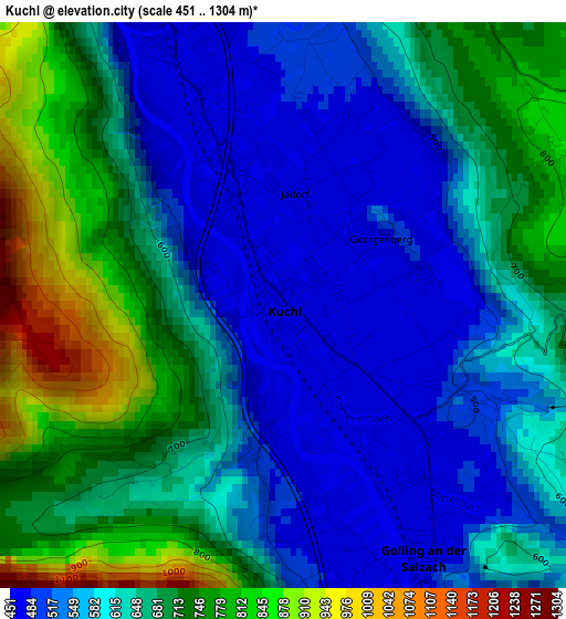
Below is the Elevation map of Kuchl, which displays elevation range with different colors. Scale of the first map is from 451 to 1304 m (1480 to 4278 ft) with average elevation of 634.5 meters (=2082 ft) [note 1]
These maps also provides idea of topography and contour of this city, they are displayed at different zoom levels. More info about maps, scale and edge coordinates you can find below images.
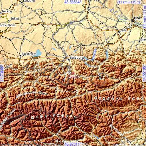
| \ | Map #1 | Topo.Map |
| Scale [m] | 451..1304 m | × |
| Scale [ft] | 1480..4278 ft | × |
| Average | 634.5 m = 2082 ft | × |
| Width | 6.59 km = 4.1 mi | 210.8 km = 131 mi |
| Height | 6.59 km = 4.1 mi | 210.8 km = 131 mi |
| ↑Max Latitude | 47.656079° | 48.56564° |
| Latitude at center | 47.62647° | 47.62647° |
| ↓Min Latitude | 47.596844° | 46.67011° |
| ← Min Longitude | 13.100855° | 11.73855° |
| Longitude center | 13.1448° | 13.1448° |
| →Max Longitude | 13.188745° | 14.55105° |
Nearby cities:
Cities around Kuchl sort by population:
• Hallein elevation 447 m
7.2 km,  332°
332°
• Oberalm 450 m
8.8 km,  337°
337°
• Neualm 444 m
8.6 km, 330°
• Burgfried 448 m
6.5 km, 337°
• Golling an der Salzach 469 m
3.4 km,  150°
150°
• Georgenberg 466 m
0.9 km,  27°
27°
• Adnet 487 m
8 km,  352°
352°
• Vigaun 458 m
4.6 km, 349°
• Au 608 m
10.1 km,  324°
324°
• Obergäu 474 m
4.7 km, 150°
• Taugl 856 m
4.9 km,  61°
61°
• Scheffau am Tennengebirge 497 m
7.1 km,  126°
126°
Multilingual:
 En español:
Kuchl elevación 466 m.
 En France:
Kuchl élévation 466 m.


Sources and notes:
- [note 1] Map square and city borders are not equal. Map elevation data is calculated only from area inside that square.
- [src 1] Elevation data from geonames database provided with same terms of usage.
- [src 2] The elevation map of Kuchl is generated using elevation data from NASA's 3 arcsec (90m) resolution SRTM data.
- [src 3] Base (background) map © OpenStreetMap contributors tiles are generated by Geofabrik and OpenTopoMap.
Copyright & License:
This Kuchl Elevation Map is licensed under CC BY-SA. You may reuse any part from this page, if you give a proper credit by linking to this URL:
 More info on terms of use page.