Kalwang elevation
Kalwang (Styria, Politischer Bezirk Leoben), Austria elevation is 753 meters and Kalwang elevation in feet is 2470 ft above sea level [src 1]. Kalwang is a seat of a third-order administrative division (feature code) with elevation that is 244 meters (801 ft) bigger than average city elevation in Austria.
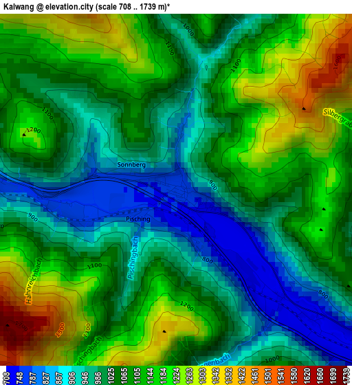
Below is the Elevation map of Kalwang, which displays elevation range with different colors. Scale of the first map is from 708 to 1739 m (2323 to 5705 ft) with average elevation of 1066.6 meters (=3499 ft) [note 1]
These maps also provides idea of topography and contour of this city, they are displayed at different zoom levels. More info about maps, scale and edge coordinates you can find below images.
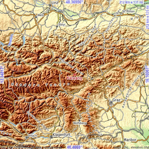
| \ | Map #1 | Topo.Map |
| Scale [m] | 708..1739 m | × |
| Scale [ft] | 2323..5705 ft | × |
| Average | 1066.6 m = 3499 ft | × |
| Width | 6.61 km = 4.1 mi | 211.6 km = 131.5 mi |
| Height | 6.61 km = 4.1 mi | 211.6 km = 131.5 mi |
| ↑Max Latitude | 47.456502° | 48.36956° |
| Latitude at center | 47.42678° | 47.42678° |
| ↓Min Latitude | 47.397041° | 46.4668° |
| ← Min Longitude | 14.710475° | 13.34817° |
| Longitude center | 14.75442° | 14.75442° |
| →Max Longitude | 14.798365° | 16.16067° |
Nearby cities:
Cities around Kalwang sort by population:
• Trofaiach elevation 660 m
19 km,  90°
90°
• Eisenerz 854 m
15.3 km,  39°
39°
• Mautern in Steiermark 728 m
6.6 km,  116°
116°
• Vordernberg 827 m
19.3 km,  69°
69°
• Kammern im Liesingtal 666 m
11.9 km,  108°
108°
• Seckau 848 m
17.9 km,  173°
173°
• Wald am Schoberpaß 843 m
6.4 km,  292°
292°
• Traboch 619 m
18.3 km, 107°
• Treglwang 730 m
13.4 km, 293°
• Sankt Marein bei Knittelfeld 705 m
18.8 km,  154°
154°
• Johnsbach 1067 m
17.5 km,  312°
312°
• Gaal 898 m
18.3 km,  200°
200°
Multilingual:
 En español:
Kalwang elevación 753 m.
 En France:
Kalwang élévation 753 m.


Sources and notes:
- [note 1] Map square and city borders are not equal. Map elevation data is calculated only from area inside that square.
- [src 1] Elevation data from geonames database provided with same terms of usage.
- [src 2] The elevation map of Kalwang is generated using elevation data from NASA's 3 arcsec (90m) resolution SRTM data.
- [src 3] Base (background) map © OpenStreetMap contributors tiles are generated by Geofabrik and OpenTopoMap.
Copyright & License:
This Kalwang Elevation Map is licensed under CC BY-SA. You may reuse any part from this page, if you give a proper credit by linking to this URL:
 More info on terms of use page.