Moschendorf elevation
Moschendorf (Burgenland, Politischer Bezirk Güssing), Austria elevation is 206 meters and Moschendorf elevation in feet is 676 ft above sea level [src 1]. Moschendorf is a seat of a third-order administrative division (feature code) with elevation that is 303 meters (994 ft) smaller than average city elevation in Austria.
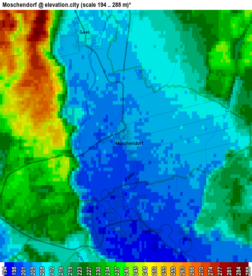
Below is the Elevation map of Moschendorf, which displays elevation range with different colors. Scale of the first map is from 194 to 288 m (636 to 945 ft) with average elevation of 218 meters (=715 ft) [note 1]
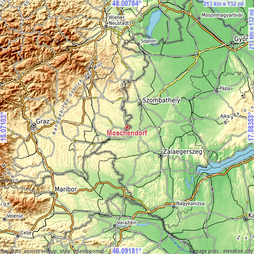
These maps also provides idea of topography and contour of this city, they are displayed at different zoom levels. More info about maps, scale and edge coordinates you can find below images.
| \ | Map #1 | Topo.Map |
| Scale [m] | 194..288 m | × |
| Scale [ft] | 636..945 ft | × |
| Average | 218 m = 715 ft | × |
| Width | 6.66 km = 4.1 mi | 213 km = 132.4 mi |
| Height | 6.66 km = 4.1 mi | 213 km = 132.4 mi |
| ↑Max Latitude | 47.088359° | 48.00784° |
| Latitude at center | 47.05843° | 47.05843° |
| ↓Min Latitude | 47.028484° | 46.09181° |
| ← Min Longitude | 16.433335° | 15.07103° |
| Longitude center | 16.47728° | 16.47728° |
| →Max Longitude | 16.521225° | 17.88353° |
Nearby cities:
Cities around Moschendorf sort by population:
• Güssing elevation 232 m
11.6 km,  270°
270°
• Kohfidisch 256 m
15.8 km,  324°
324°
• Güttenbach 284 m
17.8 km,  308°
308°
• Sankt Michael im Burgenland 252 m
17.4 km,  296°
296°
• Strem 209 m
5 km,  252°
252°
• Neustift bei Güssing 251 m
16.9 km,  257°
257°
• Eberau 215 m
5.6 km,  346°
346°
• Inzenhof 275 m
13 km, 249°
• Tobaj 233 m
13.7 km,  281°
281°
• Heiligenbrunn 211 m
5.8 km,  232°
232°
• Kleinmürbisch 249 m
11.9 km, 256°
• Tschanigraben 296 m
14.2 km, 250°
Multilingual:
 En español:
Moschendorf elevación 206 m.
 En France:
Moschendorf élévation 206 m.
 Auf Deutsch:
Moschendorf höhe über dem Meeresspiegel ist 206 m.

Sources and notes:
- [note 1] Map square and city borders are not equal. Map elevation data is calculated only from area inside that square.
- [src 1] Elevation data from geonames database provided with same terms of usage.
- [src 2] The elevation map of Moschendorf is generated using elevation data from NASA's 3 arcsec (90m) resolution SRTM data.
- [src 3] Base (background) map © OpenStreetMap contributors tiles are generated by Geofabrik and OpenTopoMap.
Copyright & License:
This Moschendorf Elevation Map is licensed under CC BY-SA. You may reuse any part from this page, if you give a proper credit by linking to this URL:
 More info on terms of use page.