Sankt Michael im Burgenland elevation
Sankt Michael im Burgenland (Burgenland, Politischer Bezirk Güssing), Austria elevation is 252 meters and Sankt Michael im Burgenland elevation in feet is 827 ft above sea level [src 1]. Sankt Michael im Burgenland is a seat of a third-order administrative division (feature code) with elevation that is 257 meters (843 ft) smaller than average city elevation in Austria.
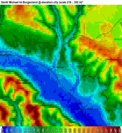
Below is the Elevation map of Sankt Michael im Burgenland, which displays elevation range with different colors. Scale of the first map is from 218 to 352 m (715 to 1155 ft) with average elevation of 270.3 meters (=887 ft) [note 1]
These maps also provides idea of topography and contour of this city, they are displayed at different zoom levels. More info about maps, scale and edge coordinates you can find below images.
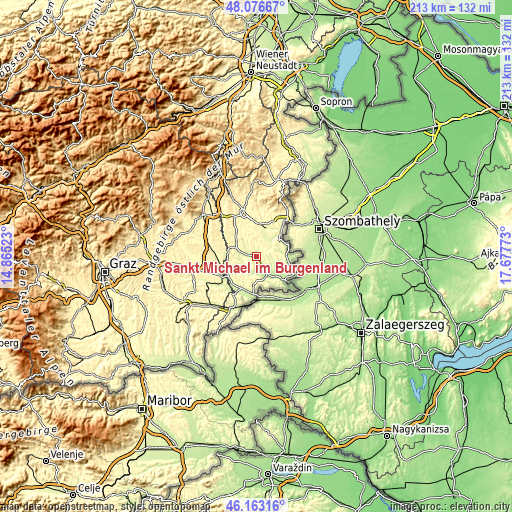
| \ | Map #1 | Topo.Map |
| Scale [m] | 218..352 m | × |
| Scale [ft] | 715..1155 ft | × |
| Average | 270.3 m = 887 ft | × |
| Width | 6.65 km = 4.1 mi | 212.8 km = 132.2 mi |
| Height | 6.65 km = 4.1 mi | 212.7 km = 132.2 mi |
| ↑Max Latitude | 47.15841° | 48.07667° |
| Latitude at center | 47.12852° | 47.12852° |
| ↓Min Latitude | 47.098613° | 46.16316° |
| ← Min Longitude | 16.227535° | 14.86523° |
| Longitude center | 16.27148° | 16.27148° |
| →Max Longitude | 16.315425° | 17.67773° |
Nearby cities:
Cities around Sankt Michael im Burgenland sort by population:
• Güssing elevation 232 m
8.7 km,  152°
152°
• Stegersbach 286 m
9 km,  298°
298°
• Olbendorf 310 m
8.1 km,  318°
318°
• Neuberg im Burgenland 303 m
4.6 km,  349°
349°
• Kohfidisch 256 m
8.3 km,  51°
51°
• Güttenbach 284 m
3.5 km,  26°
26°
• Bocksdorf 242 m
7.3 km,  282°
282°
• Kukmirn 255 m
7.5 km,  218°
218°
• Mischendorf 271 m
7.8 km,  24°
24°
• Rohr im Burgenland 252 m
8 km,  260°
260°
• Tobaj 233 m
5.5 km,  156°
156°
• Heugraben 247 m
6.2 km, 259°
Multilingual:
 En español:
Sankt Michael im Burgenland elevación 252 m.
 En France:
Sankt Michael im Burgenland élévation 252 m.
 Auf Deutsch:
Sankt Michael im Burgenland höhe über dem Meeresspiegel ist 252 m.
 На русском:
Санкт Михель (Бургенланд) высота над уровнем моря 252 м
Sources and notes:
- [note 1] Map square and city borders are not equal. Map elevation data is calculated only from area inside that square.
- [src 1] Elevation data from geonames database provided with same terms of usage.
- [src 2] The elevation map of Sankt Michael im Burgenland is generated using elevation data from NASA's 3 arcsec (90m) resolution SRTM data.
- [src 3] Base (background) map © OpenStreetMap contributors tiles are generated by Geofabrik and OpenTopoMap.
Copyright & License:
This Sankt Michael im Burgenland Elevation Map is licensed under CC BY-SA. You may reuse any part from this page, if you give a proper credit by linking to this URL:
 More info on terms of use page.