Obervellach elevation
Obervellach (Carinthia, Politischer Bezirk Spittal an der Drau), Austria elevation is 802 meters and Obervellach elevation in feet is 2631 ft above sea level [src 1]. Obervellach is a seat of a third-order administrative division (feature code) with elevation that is 293 meters (961 ft) bigger than average city elevation in Austria.
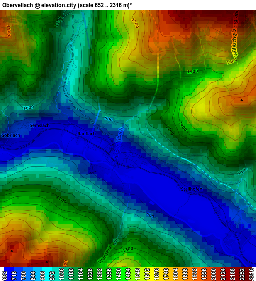
Below is the Elevation map of Obervellach, which displays elevation range with different colors. Scale of the first map is from 652 to 2316 m (2139 to 7598 ft) with average elevation of 1223.2 meters (=4013 ft) [note 1]
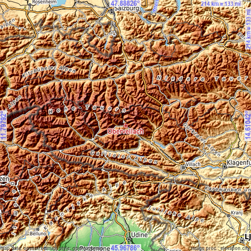
These maps also provides idea of topography and contour of this city, they are displayed at different zoom levels. More info about maps, scale and edge coordinates you can find below images.
| \ | Map #1 | Topo.Map |
| Scale [m] | 652..2316 m | × |
| Scale [ft] | 2139..7598 ft | × |
| Average | 1223.2 m = 4013 ft | × |
| Width | 6.67 km = 4.1 mi | 213.5 km = 132.7 mi |
| Height | 6.67 km = 4.1 mi | 213.5 km = 132.7 mi |
| ↑Max Latitude | 46.966668° | 47.88826° |
| Latitude at center | 46.93667° | 46.93667° |
| ↓Min Latitude | 46.906655° | 45.96786° |
| ← Min Longitude | 13.160225° | 11.79792° |
| Longitude center | 13.20417° | 13.20417° |
| →Max Longitude | 13.248115° | 14.61042° |
Nearby cities:
Cities around Obervellach sort by population:
• Bad Gastein elevation 998 m
20.6 km,  345°
345°
• Steinfeld 623 m
20.1 km,  170°
170°
• Möllbrücke 558 m
17 km,  131°
131°
• Sachsenburg 557 m
16.6 km,  136°
136°
• Greifenburg 640 m
20.8 km,  185°
185°
• Lendorf 590 m
20.6 km,  123°
123°
• Mühldorf 714 m
14.2 km, 126°
• Stall 967 m
13.7 km,  248°
248°
• Flattach 814 m
5.3 km,  272°
272°
• Rangersdorf 860 m
21.2 km, 246°
• Mörtschach 1150 m
21.8 km, 266°
• Berg im Drautal 733 m
21.5 km, 194°
Multilingual:
 En español:
Obervellach elevación 802 m.
 En France:
Obervellach élévation 802 m.
 Auf Deutsch:
Obervellach höhe über dem Meeresspiegel ist 802 m.

Sources and notes:
- [note 1] Map square and city borders are not equal. Map elevation data is calculated only from area inside that square.
- [src 1] Elevation data from geonames database provided with same terms of usage.
- [src 2] The elevation map of Obervellach is generated using elevation data from NASA's 3 arcsec (90m) resolution SRTM data.
- [src 3] Base (background) map © OpenStreetMap contributors tiles are generated by Geofabrik and OpenTopoMap.
Copyright & License:
This Obervellach Elevation Map is licensed under CC BY-SA. You may reuse any part from this page, if you give a proper credit by linking to this URL:
 More info on terms of use page.