Stall elevation
Stall (Carinthia, Politischer Bezirk Spittal an der Drau), Austria elevation is 967 meters and Stall elevation in feet is 3173 ft above sea level [src 1]. Stall is a seat of a third-order administrative division (feature code) with elevation that is 458 meters (1503 ft) bigger than average city elevation in Austria.
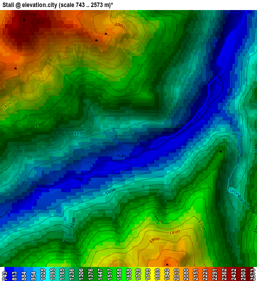
Below is the Elevation map of Stall, which displays elevation range with different colors. Scale of the first map is from 743 to 2573 m (2438 to 8442 ft) with average elevation of 1360.9 meters (=4465 ft) [note 1]
These maps also provides idea of topography and contour of this city, they are displayed at different zoom levels. More info about maps, scale and edge coordinates you can find below images.
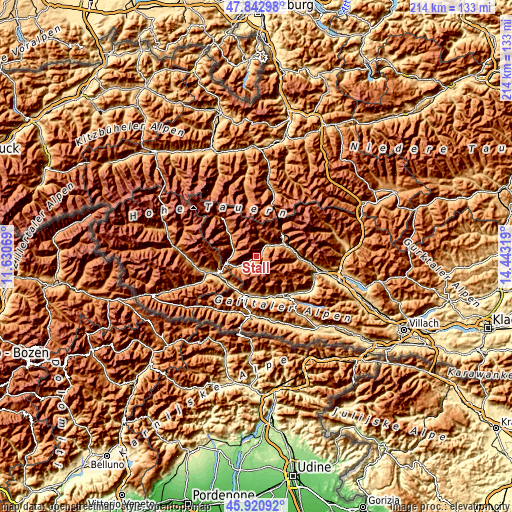
| \ | Map #1 | Topo.Map |
| Scale [m] | 743..2573 m | × |
| Scale [ft] | 2438..8442 ft | × |
| Average | 1360.9 m = 4465 ft | × |
| Width | 6.68 km = 4.2 mi | 213.7 km = 132.8 mi |
| Height | 6.68 km = 4.2 mi | 213.7 km = 132.8 mi |
| ↑Max Latitude | 46.920584° | 47.84298° |
| Latitude at center | 46.89056° | 46.89056° |
| ↓Min Latitude | 46.86052° | 45.92092° |
| ← Min Longitude | 12.992995° | 11.63069° |
| Longitude center | 13.03694° | 13.03694° |
| →Max Longitude | 13.080885° | 14.44319° |
Nearby cities:
Cities around Stall sort by population:
• Dölsach elevation 836 m
16.1 km,  244°
244°
• Winklern 977 m
12.5 km,  261°
261°
• Dellach im Drautal 618 m
17.3 km,  169°
169°
• Obervellach 802 m
13.7 km,  68°
68°
• Nikolsdorf 770 m
15 km,  218°
218°
• Irschen 822 m
14.9 km,  183°
183°
• Flattach 814 m
9.1 km,  54°
54°
• Rangersdorf 860 m
7.5 km, 242°
• Oberdrauburg 641 m
17.2 km,  197°
197°
• Mörtschach 1150 m
9.8 km,  292°
292°
• Berg im Drautal 733 m
17.4 km,  154°
154°
• Großkirchheim 1012 m
14.1 km,  310°
310°
Multilingual:
 En español:
Stall elevación 967 m.
 En France:
Stall élévation 967 m.


Sources and notes:
- [note 1] Map square and city borders are not equal. Map elevation data is calculated only from area inside that square.
- [src 1] Elevation data from geonames database provided with same terms of usage.
- [src 2] The elevation map of Stall is generated using elevation data from NASA's 3 arcsec (90m) resolution SRTM data.
- [src 3] Base (background) map © OpenStreetMap contributors tiles are generated by Geofabrik and OpenTopoMap.
Copyright & License:
This Stall Elevation Map is licensed under CC BY-SA. You may reuse any part from this page, if you give a proper credit by linking to this URL:
 More info on terms of use page.