Dellach im Drautal elevation
Dellach im Drautal (Carinthia, Politischer Bezirk Spittal an der Drau), Austria elevation is 618 meters and Dellach im Drautal elevation in feet is 2028 ft above sea level [src 1]. Dellach im Drautal is a seat of a third-order administrative division (feature code) with elevation that is 109 meters (358 ft) bigger than average city elevation in Austria.
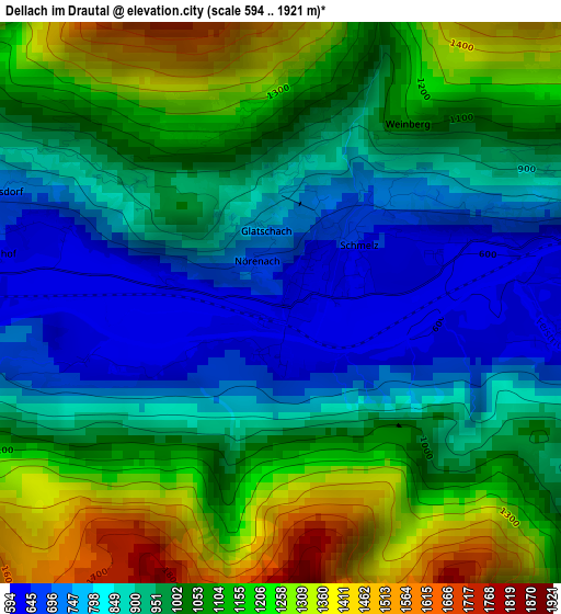
Below is the Elevation map of Dellach im Drautal, which displays elevation range with different colors. Scale of the first map is from 594 to 1921 m (1949 to 6302 ft) with average elevation of 1005 meters (=3297 ft) [note 1]
These maps also provides idea of topography and contour of this city, they are displayed at different zoom levels. More info about maps, scale and edge coordinates you can find below images.
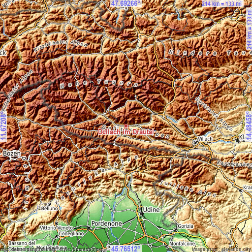
| \ | Map #1 | Topo.Map |
| Scale [m] | 594..1921 m | × |
| Scale [ft] | 1949..6302 ft | × |
| Average | 1005 m = 3297 ft | × |
| Width | 6.7 km = 4.2 mi | 214.3 km = 133.2 mi |
| Height | 6.7 km = 4.2 mi | 214.3 km = 133.2 mi |
| ↑Max Latitude | 46.767609° | 47.69266° |
| Latitude at center | 46.7375° | 46.7375° |
| ↓Min Latitude | 46.707374° | 45.76512° |
| ← Min Longitude | 13.034385° | 11.67208° |
| Longitude center | 13.07833° | 13.07833° |
| →Max Longitude | 13.122275° | 14.48458° |
Nearby cities:
Cities around Dellach im Drautal sort by population:
• Kötschach elevation 800 m
8.3 km,  221°
221°
• Steinfeld 623 m
13.2 km,  80°
80°
• Greifenburg 640 m
7.9 km, 79°
• Dellach 673 m
8.4 km,  179°
179°
• Nikolsdorf 770 m
13.7 km,  293°
293°
• Stall 967 m
17.3 km,  349°
349°
• Kirchbach 639 m
13.4 km,  142°
142°
• Irschen 822 m
4.6 km,  298°
298°
• Rangersdorf 860 m
16.8 km,  324°
324°
• Oberdrauburg 641 m
8.3 km,  274°
274°
• Lavant 656 m
19.5 km, 290°
• Berg im Drautal 733 m
4.5 km,  73°
73°
Multilingual:
 En español:
Dellach im Drautal elevación 618 m.
 En France:
Dellach im Drautal élévation 618 m.
 Auf Deutsch:
Dellach im Drautal höhe über dem Meeresspiegel ist 618 m.
 На русском:
Деллах-им-Драуталь высота над уровнем моря 618 м
Sources and notes:
- [note 1] Map square and city borders are not equal. Map elevation data is calculated only from area inside that square.
- [src 1] Elevation data from geonames database provided with same terms of usage.
- [src 2] The elevation map of Dellach im Drautal is generated using elevation data from NASA's 3 arcsec (90m) resolution SRTM data.
- [src 3] Base (background) map © OpenStreetMap contributors tiles are generated by Geofabrik and OpenTopoMap.
Copyright & License:
This Dellach im Drautal Elevation Map is licensed under CC BY-SA. You may reuse any part from this page, if you give a proper credit by linking to this URL:
 More info on terms of use page.