Bad Gastein elevation
Bad Gastein (Salzburg, Politischer Bezirk Sankt Johann im Pongau), Austria elevation is 998 meters and Bad Gastein elevation in feet is 3274 ft above sea level [src 1]. Bad Gastein is a seat of a third-order administrative division (feature code) with elevation that is 489 meters (1604 ft) bigger than average city elevation in Austria.
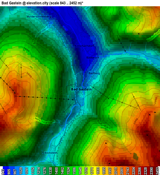
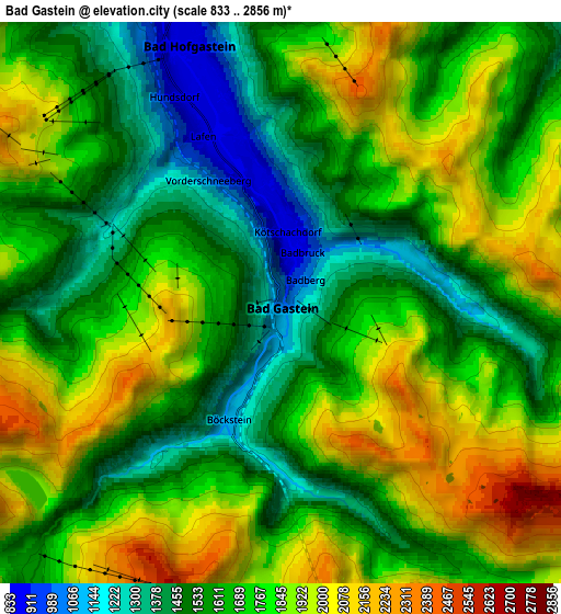
Below is the Elevation map of Bad Gastein, which displays elevation range with different colors. Scale of the first map is from 843 to 2452 m (2766 to 8045 ft) with average elevation of 1514.6 meters (=4969 ft) [note 1]
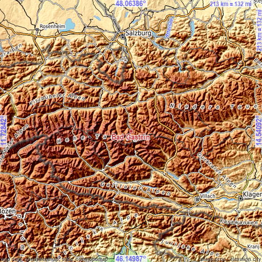
These maps also provides idea of topography and contour of this city, they are displayed at different zoom levels. More info about maps, scale and edge coordinates you can find below images.
| \ | Map #1 | Map #2 | Topo.Map |
| Scale [m] | 843..2452 m | 833..2856 m | × |
| Scale [ft] | 2766..8045 ft | 2733..9370 ft | × |
| Average | 1514.6 m = 4969 ft | 1707.4 m = 5602 ft | × |
| Width | 6.65 km = 4.1 mi | 13.3 km = 8.3 mi | 212.8 km = 132.2 mi |
| Height | 6.65 km = 4.1 mi | 13.3 km = 8.3 mi | 212.8 km = 132.2 mi |
| ↑Max Latitude | 47.145367° | 47.175248° | 48.06386° |
| Latitude at center | 47.11547° | 47.11547° | 47.11547° |
| ↓Min Latitude | 47.085556° | 47.055625° | 46.14987° |
| ← Min Longitude | 13.090725° | 13.046779° | 11.72842° |
| Longitude center | 13.13467° | 13.13467° | 13.13467° |
| →Max Longitude | 13.178615° | 13.222561° | 14.54092° |
Nearby cities:
Cities around Bad Gastein sort by population:
• Grossarl elevation 916 m
14 km,  20°
20°
• Schwarzach im Pongau 594 m
22.8 km,  3°
3°
• Bad Hofgastein 836 m
6.9 km,  336°
336°
• Anger 842 m
5 km,  334°
334°
• Rauris 945 m
16.3 km,  319°
319°
• Dorfgastein 819 m
14.3 km,  350°
350°
• Kleinarl 1001 m
22.8 km,  37°
37°
• Obervellach 802 m
20.6 km,  165°
165°
• Hüttschlag 974 m
10 km,  47°
47°
• Lend 640 m
21.3 km, 342°
• Flattach 814 m
19.7 km,  180°
180°
• Goldegg 822 m
22.8 km, 353°
Multilingual:
 En español:
Bad Gastein elevación 998 m.
 En France:
Bad Gastein élévation 998 m.
 Auf Deutsch:
Bad Gastein höhe über dem Meeresspiegel ist 998 m.

Sources and notes:
- [note 1] Map square and city borders are not equal. Map elevation data is calculated only from area inside that square.
- [src 1] Elevation data from geonames database provided with same terms of usage.
- [src 2] The elevation map of Bad Gastein is generated using elevation data from NASA's 3 arcsec (90m) resolution SRTM data.
- [src 3] Base (background) map © OpenStreetMap contributors tiles are generated by Geofabrik and OpenTopoMap.
Copyright & License:
This Bad Gastein Elevation Map is licensed under CC BY-SA. You may reuse any part from this page, if you give a proper credit by linking to this URL:
 More info on terms of use page.