Randegg elevation
Randegg (Lower Austria, Politischer Bezirk Scheibbs), Austria elevation is 361 meters and Randegg elevation in feet is 1184 ft above sea level [src 1]. Randegg is a seat of a third-order administrative division (feature code) with elevation that is 148 meters (486 ft) smaller than average city elevation in Austria.
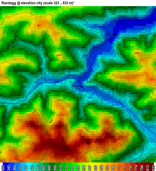
Below is the Elevation map of Randegg, which displays elevation range with different colors. Scale of the first map is from 323 to 833 m (1060 to 2733 ft) with average elevation of 542.3 meters (=1779 ft) [note 1]
These maps also provides idea of topography and contour of this city, they are displayed at different zoom levels. More info about maps, scale and edge coordinates you can find below images.
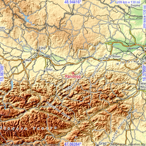
| \ | Map #1 | Topo.Map |
| Scale [m] | 323..833 m | × |
| Scale [ft] | 1060..2733 ft | × |
| Average | 542.3 m = 1779 ft | × |
| Width | 6.54 km = 4.1 mi | 209.2 km = 130 mi |
| Height | 6.54 km = 4.1 mi | 209.2 km = 130 mi |
| ↑Max Latitude | 48.04137° | 48.94416° |
| Latitude at center | 48.01198° | 48.01198° |
| ↓Min Latitude | 47.982573° | 47.06264° |
| ← Min Longitude | 14.929395° | 13.56709° |
| Longitude center | 14.97334° | 14.97334° |
| →Max Longitude | 15.017285° | 16.37959° |
Nearby cities:
Cities around Randegg sort by population:
• Euratsfeld elevation 312 m
8.4 km,  338°
338°
• Gaming 427 m
12.6 km,  137°
137°
• Ferschnitz 282 m
9.2 km,  5°
5°
• Ybbsitz 411 m
9.4 km,  220°
220°
• Gresten 408 m
4.9 km,  127°
127°
• Winklarn 294 m
12.8 km,  313°
313°
• Neuhofen an der Ybbs 318 m
10.2 km,  300°
300°
• Steinakirchen am Forst 321 m
8.5 km,  40°
40°
• Wang 321 m
5.4 km,  46°
46°
• Wolfpassing 298 m
10 km, 42°
• Reinsberg 477 m
7.8 km,  111°
111°
• Höfling 327 m
6.7 km, 44°
Multilingual:
 En español:
Randegg elevación 361 m.
 En France:
Randegg élévation 361 m.


Sources and notes:
- [note 1] Map square and city borders are not equal. Map elevation data is calculated only from area inside that square.
- [src 1] Elevation data from geonames database provided with same terms of usage.
- [src 2] The elevation map of Randegg is generated using elevation data from NASA's 3 arcsec (90m) resolution SRTM data.
- [src 3] Base (background) map © OpenStreetMap contributors tiles are generated by Geofabrik and OpenTopoMap.
Copyright & License:
This Randegg Elevation Map is licensed under CC BY-SA. You may reuse any part from this page, if you give a proper credit by linking to this URL:
 More info on terms of use page.