Wolfpassing elevation
Wolfpassing (Lower Austria, Politischer Bezirk Scheibbs), Austria elevation is 298 meters and Wolfpassing elevation in feet is 978 ft above sea level [src 1]. Wolfpassing is a seat of a third-order administrative division (feature code) with elevation that is 211 meters (692 ft) smaller than average city elevation in Austria.
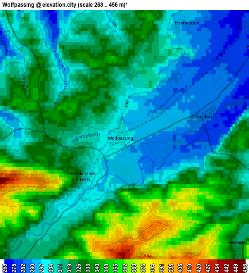
Below is the Elevation map of Wolfpassing, which displays elevation range with different colors. Scale of the first map is from 268 to 456 m (879 to 1496 ft) with average elevation of 320.4 meters (=1051 ft) [note 1]
These maps also provides idea of topography and contour of this city, they are displayed at different zoom levels. More info about maps, scale and edge coordinates you can find below images.
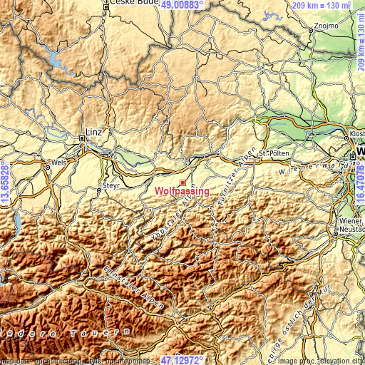
| \ | Map #1 | Topo.Map |
| Scale [m] | 268..456 m | × |
| Scale [ft] | 879..1496 ft | × |
| Average | 320.4 m = 1051 ft | × |
| Width | 6.53 km = 4.1 mi | 208.9 km = 129.8 mi |
| Height | 6.53 km = 4.1 mi | 208.9 km = 129.8 mi |
| ↑Max Latitude | 48.107202° | 49.00883° |
| Latitude at center | 48.07785° | 48.07785° |
| ↓Min Latitude | 48.048481° | 47.12972° |
| ← Min Longitude | 15.020585° | 13.65828° |
| Longitude center | 15.06453° | 15.06453° |
| →Max Longitude | 15.108475° | 16.47078° |
Nearby cities:
Cities around Wolfpassing sort by population:
• Ybbs an der Donau elevation 218 m
10 km,  8°
8°
• Wieselburg 258 m
8 km,  39°
39°
• Blindenmarkt 246 m
8 km,  313°
313°
• Euratsfeld 312 m
9.9 km,  272°
272°
• Purgstall 297 m
5.6 km,  112°
112°
• Ferschnitz 282 m
6.2 km,  287°
287°
• Sankt Georgen am Ybbsfelde 266 m
10 km,  304°
304°
• Neumarkt an der Ybbs 227 m
7 km,  355°
355°
• Steinakirchen am Forst 321 m
1.5 km,  233°
233°
• Wang 321 m
4.6 km,  217°
217°
• Randegg 361 m
10 km, 222°
• Höfling 327 m
3.3 km, 218°
Multilingual:
 En español:
Wolfpassing elevación 298 m.
 En France:
Wolfpassing élévation 298 m.
 Auf Deutsch:
Wolfpassing höhe über dem Meeresspiegel ist 298 m.

Sources and notes:
- [note 1] Map square and city borders are not equal. Map elevation data is calculated only from area inside that square.
- [src 1] Elevation data from geonames database provided with same terms of usage.
- [src 2] The elevation map of Wolfpassing is generated using elevation data from NASA's 3 arcsec (90m) resolution SRTM data.
- [src 3] Base (background) map © OpenStreetMap contributors tiles are generated by Geofabrik and OpenTopoMap.
Copyright & License:
This Wolfpassing Elevation Map is licensed under CC BY-SA. You may reuse any part from this page, if you give a proper credit by linking to this URL:
 More info on terms of use page.