Winklarn elevation
Winklarn (Lower Austria, Politischer Bezirk Amstetten), Austria elevation is 294 meters and Winklarn elevation in feet is 965 ft above sea level [src 1]. Winklarn is a seat of a third-order administrative division (feature code) with elevation that is 215 meters (705 ft) smaller than average city elevation in Austria.
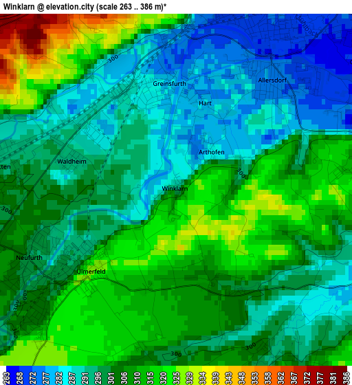
Below is the Elevation map of Winklarn, which displays elevation range with different colors. Scale of the first map is from 263 to 386 m (863 to 1266 ft) with average elevation of 301.5 meters (=989 ft) [note 1]
These maps also provides idea of topography and contour of this city, they are displayed at different zoom levels. More info about maps, scale and edge coordinates you can find below images.
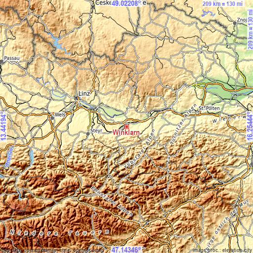
| \ | Map #1 | Topo.Map |
| Scale [m] | 263..386 m | × |
| Scale [ft] | 863..1266 ft | × |
| Average | 301.5 m = 989 ft | × |
| Width | 6.53 km = 4.1 mi | 208.9 km = 129.8 mi |
| Height | 6.53 km = 4.1 mi | 208.9 km = 129.8 mi |
| ↑Max Latitude | 48.120695° | 49.02208° |
| Latitude at center | 48.09135° | 48.09135° |
| ↓Min Latitude | 48.061989° | 47.14346° |
| ← Min Longitude | 14.804245° | 13.44194° |
| Longitude center | 14.84819° | 14.84819° |
| →Max Longitude | 14.892135° | 16.25444° |
Nearby cities:
Cities around Winklarn sort by population:
• Amstetten elevation 277 m
3.9 km,  26°
26°
• Euratsfeld 312 m
6.3 km,  99°
99°
• Mauer bei Amstetten 298 m
3.6 km,  279°
279°
• Hausmening 303 m
3.4 km,  227°
227°
• Zeillern 292 m
5.3 km,  325°
325°
• Aschbach Markt 307 m
7.3 km,  253°
253°
• Neufurth 299 m
3 km,  242°
242°
• Oehling 297 m
3.7 km,  285°
285°
• Greinsfurth 280 m
1.9 km,  350°
350°
• Ardagger Stift 332 m
6.6 km, 350°
• Neuhofen an der Ybbs 318 m
3.7 km,  172°
172°
• Stephanshart 303 m
6.9 km,  340°
340°
Multilingual:
 En español:
Winklarn elevación 294 m.
 En France:
Winklarn élévation 294 m.
 Auf Deutsch:
Winklarn höhe über dem Meeresspiegel ist 294 m.

Sources and notes:
- [note 1] Map square and city borders are not equal. Map elevation data is calculated only from area inside that square.
- [src 1] Elevation data from geonames database provided with same terms of usage.
- [src 2] The elevation map of Winklarn is generated using elevation data from NASA's 3 arcsec (90m) resolution SRTM data.
- [src 3] Base (background) map © OpenStreetMap contributors tiles are generated by Geofabrik and OpenTopoMap.
Copyright & License:
This Winklarn Elevation Map is licensed under CC BY-SA. You may reuse any part from this page, if you give a proper credit by linking to this URL:
 More info on terms of use page.