Spitz elevation
Spitz (Lower Austria, Politischer Bezirk Krems), Austria elevation is 223 meters and Spitz elevation in feet is 732 ft above sea level [src 1]. Spitz is a seat of a third-order administrative division (feature code) with elevation that is 286 meters (938 ft) smaller than average city elevation in Austria.
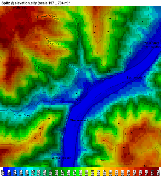
Below is the Elevation map of Spitz, which displays elevation range with different colors. Scale of the first map is from 197 to 794 m (646 to 2605 ft) with average elevation of 450.2 meters (=1477 ft) [note 1]
These maps also provides idea of topography and contour of this city, they are displayed at different zoom levels. More info about maps, scale and edge coordinates you can find below images.
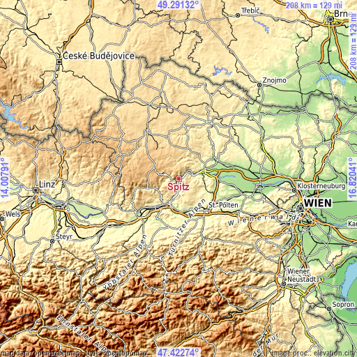
| \ | Map #1 | Topo.Map |
| Scale [m] | 197..794 m | × |
| Scale [ft] | 646..2605 ft | × |
| Average | 450.2 m = 1477 ft | × |
| Width | 6.49 km = 4 mi | 207.8 km = 129.1 mi |
| Height | 6.49 km = 4 mi | 207.8 km = 129.1 mi |
| ↑Max Latitude | 48.394788° | 49.29132° |
| Latitude at center | 48.3656° | 48.3656° |
| ↓Min Latitude | 48.336395° | 47.42274° |
| ← Min Longitude | 15.370215° | 14.00791° |
| Longitude center | 15.41416° | 15.41416° |
| →Max Longitude | 15.458105° | 16.82041° |
Nearby cities:
Cities around Spitz sort by population:
• Mautern elevation 205 m
12.5 km,  75°
75°
• Stein an der Donau 200 m
13 km,  71°
71°
• Senftenberg 435 m
12.5 km,  53°
53°
• Weißenkirchen in der Wachau 218 m
5.4 km, 48°
• Aggsbach 209 m
8 km,  185°
185°
• Weiten 344 m
13.8 km,  235°
235°
• Mühldorf 361 m
5.1 km,  281°
281°
• Dürnstein 223 m
8.5 km, 66°
• Raxendorf 516 m
10.5 km,  254°
254°
• Maria Laach am Jauerling 587 m
8.5 km,  216°
216°
• Gerolding 451 m
12.9 km,  179°
179°
• Weinzierl am Walde 643 m
7.5 km,  10°
10°
Multilingual:
 En español:
Spitz elevación 223 m.
 En France:
Spitz élévation 223 m.
 Auf Deutsch:
Spitz an der Donau höhe über dem Meeresspiegel ist 223 m.

Sources and notes:
- [note 1] Map square and city borders are not equal. Map elevation data is calculated only from area inside that square.
- [src 1] Elevation data from geonames database provided with same terms of usage.
- [src 2] The elevation map of Spitz is generated using elevation data from NASA's 3 arcsec (90m) resolution SRTM data.
- [src 3] Base (background) map © OpenStreetMap contributors tiles are generated by Geofabrik and OpenTopoMap.
Copyright & License:
This Spitz Elevation Map is licensed under CC BY-SA. You may reuse any part from this page, if you give a proper credit by linking to this URL:
 More info on terms of use page.