Weiten elevation
Weiten (Lower Austria, Politischer Bezirk Melk), Austria elevation is 344 meters and Weiten elevation in feet is 1129 ft above sea level [src 1]. Weiten is a seat of a third-order administrative division (feature code) with elevation that is 165 meters (541 ft) smaller than average city elevation in Austria.
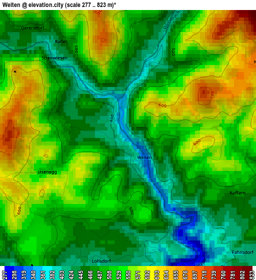
Below is the Elevation map of Weiten, which displays elevation range with different colors. Scale of the first map is from 277 to 823 m (909 to 2700 ft) with average elevation of 509.3 meters (=1671 ft) [note 1]
These maps also provides idea of topography and contour of this city, they are displayed at different zoom levels. More info about maps, scale and edge coordinates you can find below images.
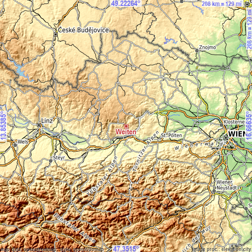
| \ | Map #1 | Topo.Map |
| Scale [m] | 277..823 m | × |
| Scale [ft] | 909..2700 ft | × |
| Average | 509.3 m = 1671 ft | × |
| Width | 6.5 km = 4 mi | 208.1 km = 129.3 mi |
| Height | 6.5 km = 4 mi | 208 km = 129.2 mi |
| ↑Max Latitude | 48.324868° | 49.22264° |
| Latitude at center | 48.29564° | 48.29564° |
| ↓Min Latitude | 48.266395° | 47.3515° |
| ← Min Longitude | 15.216155° | 13.85385° |
| Longitude center | 15.2601° | 15.2601° |
| →Max Longitude | 15.304045° | 16.66635° |
Nearby cities:
Cities around Weiten sort by population:
• Melk elevation 222 m
9.3 km,  145°
145°
• Pöchlarn 214 m
11.5 km,  202°
202°
• Klein-Pöchlarn 209 m
9.4 km, 200°
• Pöggstall 457 m
4.8 km,  300°
300°
• Leiben 327 m
5.6 km,  168°
168°
• Emmersdorf an der Donau 211 m
8.3 km,  136°
136°
• Aggsbach 209 m
10.6 km,  90°
90°
• Mühldorf 361 m
10.8 km,  36°
36°
• Raxendorf 516 m
5.2 km,  13°
13°
• Maria Taferl 435 m
10.7 km,  224°
224°
• Maria Laach am Jauerling 587 m
6.3 km,  81°
81°
• Kirchschlag 820 m
11.2 km,  345°
345°
Multilingual:
 En español:
Weiten elevación 344 m.
 En France:
Weiten élévation 344 m.


Sources and notes:
- [note 1] Map square and city borders are not equal. Map elevation data is calculated only from area inside that square.
- [src 1] Elevation data from geonames database provided with same terms of usage.
- [src 2] The elevation map of Weiten is generated using elevation data from NASA's 3 arcsec (90m) resolution SRTM data.
- [src 3] Base (background) map © OpenStreetMap contributors tiles are generated by Geofabrik and OpenTopoMap.
Copyright & License:
This Weiten Elevation Map is licensed under CC BY-SA. You may reuse any part from this page, if you give a proper credit by linking to this URL:
 More info on terms of use page.