Gerolding elevation
Gerolding (Lower Austria, Politischer Bezirk Melk), Austria elevation is 451 meters and Gerolding elevation in feet is 1480 ft above sea level [src 1]. Gerolding is a seat of a third-order administrative division (feature code) with elevation that is 58 meters (190 ft) smaller than average city elevation in Austria.
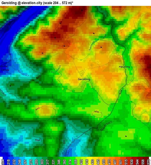
Below is the Elevation map of Gerolding, which displays elevation range with different colors. Scale of the first map is from 204 to 572 m (669 to 1877 ft) with average elevation of 375.6 meters (=1232 ft) [note 1]
These maps also provides idea of topography and contour of this city, they are displayed at different zoom levels. More info about maps, scale and edge coordinates you can find below images.
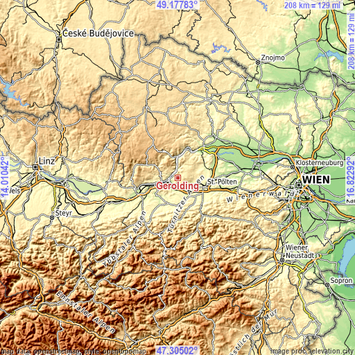
| \ | Map #1 | Topo.Map |
| Scale [m] | 204..572 m | × |
| Scale [ft] | 669..1877 ft | × |
| Average | 375.6 m = 1232 ft | × |
| Width | 6.51 km = 4 mi | 208.2 km = 129.4 mi |
| Height | 6.51 km = 4 mi | 208.2 km = 129.4 mi |
| ↑Max Latitude | 48.279254° | 49.17783° |
| Latitude at center | 48.25° | 48.25° |
| ↓Min Latitude | 48.220729° | 47.30502° |
| ← Min Longitude | 15.372725° | 14.01042° |
| Longitude center | 15.41667° | 15.41667° |
| →Max Longitude | 15.460615° | 16.82292° |
Nearby cities:
Cities around Gerolding sort by population:
• Melk elevation 222 m
6.8 km,  248°
248°
• Loosdorf 226 m
5.7 km,  192°
192°
• Prinzersdorf 268 m
9.3 km,  126°
126°
• Markersdorf an der Pielach 254 m
9.6 km,  140°
140°
• Leiben 327 m
10.5 km,  267°
267°
• Emmersdorf an der Donau 211 m
6 km,  260°
260°
• Hürm 275 m
10.5 km,  181°
181°
• Hafnerbach 274 m
6.2 km, 126°
• Aggsbach 209 m
5 km,  349°
349°
• Haunoldstein 262 m
6.1 km,  156°
156°
• Maria Laach am Jauerling 587 m
8 km,  318°
318°
• Neidling 313 m
10.4 km,  96°
96°
Multilingual:
 En español:
Gerolding elevación 451 m.
 En France:
Gerolding élévation 451 m.
 Auf Deutsch:
Gerolding höhe über dem Meeresspiegel ist 451 m.

Sources and notes:
- [note 1] Map square and city borders are not equal. Map elevation data is calculated only from area inside that square.
- [src 1] Elevation data from geonames database provided with same terms of usage.
- [src 2] The elevation map of Gerolding is generated using elevation data from NASA's 3 arcsec (90m) resolution SRTM data.
- [src 3] Base (background) map © OpenStreetMap contributors tiles are generated by Geofabrik and OpenTopoMap.
Copyright & License:
This Gerolding Elevation Map is licensed under CC BY-SA. You may reuse any part from this page, if you give a proper credit by linking to this URL:
 More info on terms of use page.