Stadl an der Mur elevation
Stadl an der Mur (Styria, Politischer Bezirk Murau), Austria elevation is 890 meters and Stadl an der Mur elevation in feet is 2920 ft above sea level [src 1]. Stadl an der Mur is a seat of a third-order administrative division (feature code) with elevation that is 381 meters (1250 ft) bigger than average city elevation in Austria.
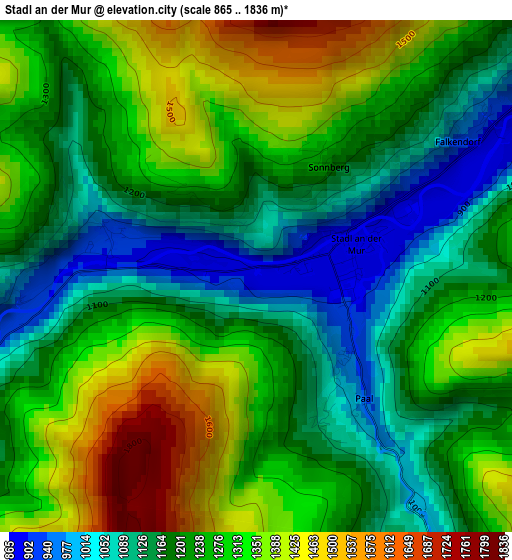
Below is the Elevation map of Stadl an der Mur, which displays elevation range with different colors. Scale of the first map is from 865 to 1836 m (2838 to 6024 ft) with average elevation of 1241.5 meters (=4073 ft) [note 1]
These maps also provides idea of topography and contour of this city, they are displayed at different zoom levels. More info about maps, scale and edge coordinates you can find below images.
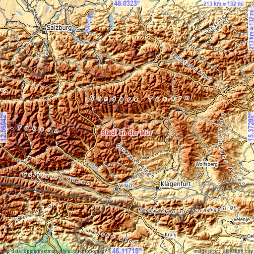
| \ | Map #1 | Topo.Map |
| Scale [m] | 865..1836 m | × |
| Scale [ft] | 2838..6024 ft | × |
| Average | 1241.5 m = 4073 ft | × |
| Width | 6.65 km = 4.1 mi | 212.9 km = 132.3 mi |
| Height | 6.65 km = 4.1 mi | 212.9 km = 132.3 mi |
| ↑Max Latitude | 47.113245° | 48.0323° |
| Latitude at center | 47.08333° | 47.08333° |
| ↓Min Latitude | 47.053398° | 46.11715° |
| ← Min Longitude | 13.922725° | 12.56042° |
| Longitude center | 13.96667° | 13.96667° |
| →Max Longitude | 14.010615° | 15.37292° |
Nearby cities:
Cities around Stadl an der Mur sort by population:
• Murau elevation 841 m
15.6 km,  78°
78°
• Tamsweg 1026 m
12.8 km,  292°
292°
• Sankt Andrä im Lungau 1129 m
15.7 km,  298°
298°
• Ranten 936 m
12.2 km,  46°
46°
• Krakaudorf 1164 m
11.6 km,  20°
20°
• Ramingstein 978 m
9.9 km,  264°
264°
• Krakauhintermühlen 1161 m
11.2 km,  6°
6°
• Schöder 1031 m
15 km,  42°
42°
• Sankt Georgen ob Murau 844 m
10.3 km, 79°
• Thomatal 1143 m
16.5 km, 263°
• Krakauschatten 1209 m
11.1 km,  0°
0°
• St. Ruprecht-Falkendorf 1051 m
4.3 km,  62°
62°
Multilingual:
 En español:
Stadl an der Mur elevación 890 m.
 En France:
Stadl an der Mur élévation 890 m.
 Auf Deutsch:
Stadl an der Mur höhe über dem Meeresspiegel ist 890 m.

Sources and notes:
- [note 1] Map square and city borders are not equal. Map elevation data is calculated only from area inside that square.
- [src 1] Elevation data from geonames database provided with same terms of usage.
- [src 2] The elevation map of Stadl an der Mur is generated using elevation data from NASA's 3 arcsec (90m) resolution SRTM data.
- [src 3] Base (background) map © OpenStreetMap contributors tiles are generated by Geofabrik and OpenTopoMap.
Copyright & License:
This Stadl an der Mur Elevation Map is licensed under CC BY-SA. You may reuse any part from this page, if you give a proper credit by linking to this URL:
 More info on terms of use page.