Ranten elevation
Ranten (Styria, Politischer Bezirk Murau), Austria elevation is 936 meters and Ranten elevation in feet is 3071 ft above sea level [src 1]. Ranten is a seat of a third-order administrative division (feature code) with elevation that is 427 meters (1401 ft) bigger than average city elevation in Austria.
Below is the Elevation map of Ranten, which displays elevation range with different colors. Scale of the first map is from 867 to 1793 m (2844 to 5883 ft) with average elevation of 1178 meters (=3865 ft) [note 1]
These maps also provides idea of topography and contour of this city, they are displayed at different zoom levels. More info about maps, scale and edge coordinates you can find below images.
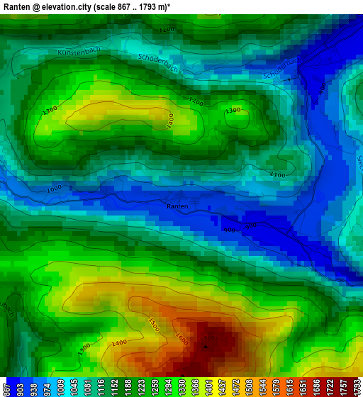
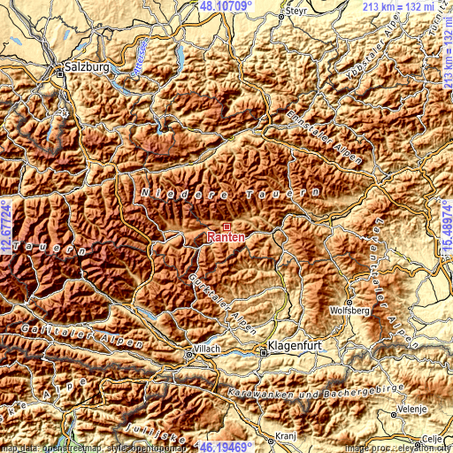
| \ | Map #1 | Topo.Map |
| Scale [m] | 867..1793 m | × |
| Scale [ft] | 2844..5883 ft | × |
| Average | 1178 m = 3865 ft | × |
| Width | 6.64 km = 4.1 mi | 212.6 km = 132.1 mi |
| Height | 6.64 km = 4.1 mi | 212.6 km = 132.1 mi |
| ↑Max Latitude | 47.189363° | 48.10709° |
| Latitude at center | 47.15949° | 47.15949° |
| ↓Min Latitude | 47.129601° | 46.19469° |
| ← Min Longitude | 14.039545° | 12.67724° |
| Longitude center | 14.08349° | 14.08349° |
| →Max Longitude | 14.127435° | 15.48974° |
Nearby cities:
Cities around Ranten sort by population:
• Murau elevation 841 m
8.5 km,  129°
129°
• Sankt Peter am Kammersberg 833 m
8.2 km,  68°
68°
• Krakaudorf 1164 m
5.3 km,  297°
297°
• Krakauhintermühlen 1161 m
8 km,  289°
289°
• Stadl an der Mur 890 m
12.2 km,  226°
226°
• Schöder 1031 m
2.9 km,  25°
25°
• Oberwölz Stadt 825 m
15.8 km, 72°
• Sankt Georgen ob Murau 844 m
6.7 km,  169°
169°
• Winklern bei Oberwölz 977 m
12.2 km, 68°
• Krakauschatten 1209 m
9.2 km, 286°
• Triebendorf 878 m
12.3 km,  112°
112°
• St. Ruprecht-Falkendorf 1051 m
8.2 km,  217°
217°
Multilingual:
 En español:
Ranten elevación 936 m.
 En France:
Ranten élévation 936 m.


Sources and notes:
- [note 1] Map square and city borders are not equal. Map elevation data is calculated only from area inside that square.
- [src 1] Elevation data from geonames database provided with same terms of usage.
- [src 2] The elevation map of Ranten is generated using elevation data from NASA's 3 arcsec (90m) resolution SRTM data.
- [src 3] Base (background) map © OpenStreetMap contributors tiles are generated by Geofabrik and OpenTopoMap.
Copyright & License:
This Ranten Elevation Map is licensed under CC BY-SA. You may reuse any part from this page, if you give a proper credit by linking to this URL:
 More info on terms of use page.