Thomatal elevation
Thomatal (Salzburg, Politischer Bezirk Tamsweg), Austria elevation is 1143 meters and Thomatal elevation in feet is 3750 ft above sea level [src 1]. Thomatal is a seat of a third-order administrative division (feature code) with elevation that is 634 meters (2080 ft) bigger than average city elevation in Austria.
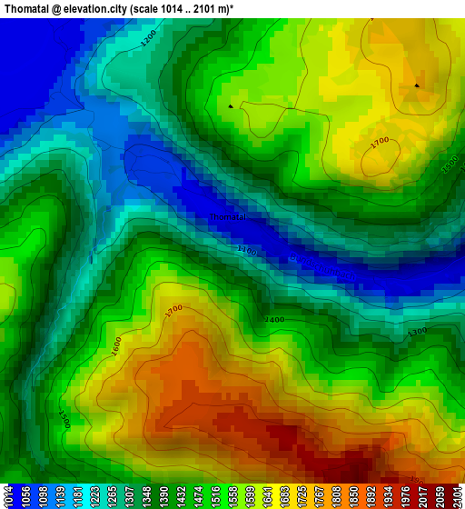
Below is the Elevation map of Thomatal, which displays elevation range with different colors. Scale of the first map is from 1014 to 2101 m (3327 to 6893 ft) with average elevation of 1462.3 meters (=4798 ft) [note 1]
These maps also provides idea of topography and contour of this city, they are displayed at different zoom levels. More info about maps, scale and edge coordinates you can find below images.
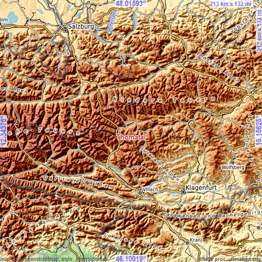
| \ | Map #1 | Topo.Map |
| Scale [m] | 1014..2101 m | × |
| Scale [ft] | 3327..6893 ft | × |
| Average | 1462.3 m = 4798 ft | × |
| Width | 6.66 km = 4.1 mi | 213 km = 132.4 mi |
| Height | 6.66 km = 4.1 mi | 213 km = 132.4 mi |
| ↑Max Latitude | 47.096595° | 48.01593° |
| Latitude at center | 47.06667° | 47.06667° |
| ↓Min Latitude | 47.036728° | 46.10019° |
| ← Min Longitude | 13.706055° | 12.34375° |
| Longitude center | 13.75° | 13.75° |
| →Max Longitude | 13.793945° | 15.15625° |
Nearby cities:
Cities around Thomatal sort by population:
• Tamsweg elevation 1026 m
8.2 km,  34°
34°
• Sankt Michael im Lungau 1088 m
9.6 km,  292°
292°
• Mariapfarr 1115 m
9.3 km,  0°
0°
• Mauterndorf 1128 m
9.3 km,  324°
324°
• Unternberg 1022 m
5.1 km,  353°
353°
• Sankt Andrä im Lungau 1129 m
9.6 km,  15°
15°
• Sankt Margarethen im Lungau 1063 m
4.3 km, 288°
• Ramingstein 978 m
6.6 km,  82°
82°
• Stadl an der Mur 890 m
16.5 km, 83°
• Rennweg am Katschberg 1162 m
11.5 km,  241°
241°
• Tweng 1435 m
17.2 km, 318°
• Muhr 1113 m
19.4 km,  280°
280°
Multilingual:
 En español:
Thomatal elevación 1143 m.
 En France:
Thomatal élévation 1143 m.
 Auf Deutsch:
Thomatal höhe über dem Meeresspiegel ist 1143 m.

Sources and notes:
- [note 1] Map square and city borders are not equal. Map elevation data is calculated only from area inside that square.
- [src 1] Elevation data from geonames database provided with same terms of usage.
- [src 2] The elevation map of Thomatal is generated using elevation data from NASA's 3 arcsec (90m) resolution SRTM data.
- [src 3] Base (background) map © OpenStreetMap contributors tiles are generated by Geofabrik and OpenTopoMap.
Copyright & License:
This Thomatal Elevation Map is licensed under CC BY-SA. You may reuse any part from this page, if you give a proper credit by linking to this URL:
 More info on terms of use page.