Waldprechting elevation
Waldprechting (Salzburg, Politischer Bezirk Salzburg-Umgebung), Austria elevation is 530 meters and Waldprechting elevation in feet is 1739 ft above sea level [src 1]. Waldprechting is a populated place (feature code) with elevation that is 21 meters (69 ft) bigger than average city elevation in Austria.
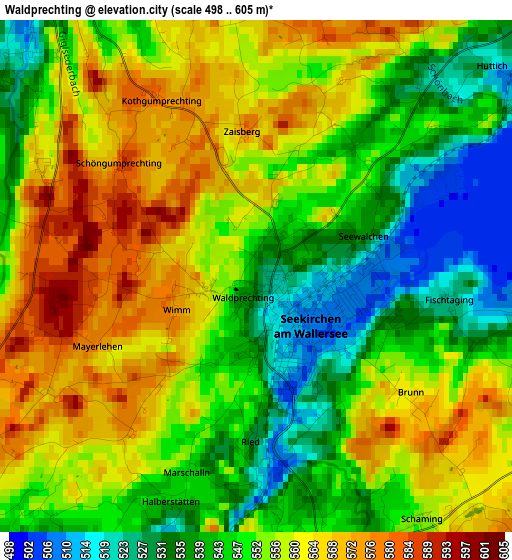
Below is the Elevation map of Waldprechting, which displays elevation range with different colors. Scale of the first map is from 498 to 605 m (1634 to 1985 ft) with average elevation of 552.2 meters (=1812 ft) [note 1]
These maps also provides idea of topography and contour of this city, they are displayed at different zoom levels. More info about maps, scale and edge coordinates you can find below images.
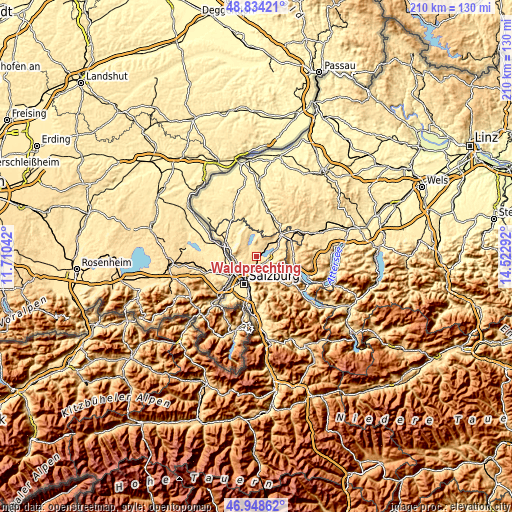
| \ | Map #1 | Topo.Map |
| Scale [m] | 498..605 m | × |
| Scale [ft] | 1634..1985 ft | × |
| Average | 552.2 m = 1812 ft | × |
| Width | 6.55 km = 4.1 mi | 209.7 km = 130.3 mi |
| Height | 6.55 km = 4.1 mi | 209.6 km = 130.2 mi |
| ↑Max Latitude | 47.929454° | 48.83421° |
| Latitude at center | 47.9° | 47.9° |
| ↓Min Latitude | 47.87053° | 46.94862° |
| ← Min Longitude | 13.072725° | 11.71042° |
| Longitude center | 13.11667° | 13.11667° |
| →Max Longitude | 13.160615° | 14.52292° |
Nearby cities:
Cities around Waldprechting sort by population:
• Henndorf am Wallersee elevation 567 m
5 km,  90°
90°
• Obertrum am See 508 m
5.1 km,  324°
324°
• Seekirchen am Wallersee 510 m
1.2 km, 90°
• Mattsee 521 m
7.5 km,  350°
350°
• Elixhausen 534 m
5.3 km,  225°
225°
• Eugendorf 551 m
3.7 km,  168°
168°
• Esch 468 m
6.9 km,  195°
195°
• Lengfelden 442 m
7.5 km,  221°
221°
• Hallwang 507 m
6.1 km, 204°
• Reitberg 622 m
6.1 km,  150°
150°
• Schleedorf 600 m
6.1 km,  24°
24°
• Seewalchen 510 m
1.2 km, 90°
Multilingual:
 En español:
Waldprechting elevación 530 m.
 En France:
Waldprechting élévation 530 m.
 Auf Deutsch:
Waldprechting höhe über dem Meeresspiegel ist 530 m.

Sources and notes:
- [note 1] Map square and city borders are not equal. Map elevation data is calculated only from area inside that square.
- [src 1] Elevation data from geonames database provided with same terms of usage.
- [src 2] The elevation map of Waldprechting is generated using elevation data from NASA's 3 arcsec (90m) resolution SRTM data.
- [src 3] Base (background) map © OpenStreetMap contributors tiles are generated by Geofabrik and OpenTopoMap.
Copyright & License:
This Waldprechting Elevation Map is licensed under CC BY-SA. You may reuse any part from this page, if you give a proper credit by linking to this URL:
 More info on terms of use page.