Mattsee elevation
Mattsee (Salzburg, Politischer Bezirk Salzburg-Umgebung), Austria elevation is 521 meters and Mattsee elevation in feet is 1709 ft above sea level [src 1]. Mattsee is a seat of a third-order administrative division (feature code) with elevation that is 12 meters (39 ft) bigger than average city elevation in Austria.
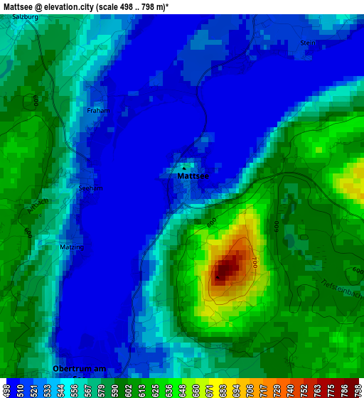
Below is the Elevation map of Mattsee, which displays elevation range with different colors. Scale of the first map is from 498 to 798 m (1634 to 2618 ft) with average elevation of 561 meters (=1841 ft) [note 1]
These maps also provides idea of topography and contour of this city, they are displayed at different zoom levels. More info about maps, scale and edge coordinates you can find below images.
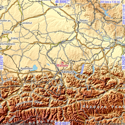
| \ | Map #1 | Topo.Map |
| Scale [m] | 498..798 m | × |
| Scale [ft] | 1634..2618 ft | × |
| Average | 561 m = 1841 ft | × |
| Width | 6.54 km = 4.1 mi | 209.4 km = 130.1 mi |
| Height | 6.54 km = 4.1 mi | 209.4 km = 130.1 mi |
| ↑Max Latitude | 47.996086° | 48.89967° |
| Latitude at center | 47.96667° | 47.96667° |
| ↓Min Latitude | 47.937237° | 47.01651° |
| ← Min Longitude | 13.056055° | 11.69375° |
| Longitude center | 13.1° | 13.1° |
| →Max Longitude | 13.143945° | 14.50625° |
Nearby cities:
Cities around Mattsee sort by population:
• Obertrum am See elevation 508 m
3.7 km,  207°
207°
• Seekirchen am Wallersee 510 m
7.8 km,  161°
161°
• Waldprechting 530 m
7.5 km,  170°
170°
• Seeham 512 m
1.7 km,  272°
272°
• Berndorf bei Salzburg 550 m
4.3 km,  317°
317°
• Schleedorf 600 m
4.2 km,  116°
116°
• Köstendorf 533 m
7.7 km,  103°
103°
• Seewalchen 510 m
7.8 km, 161°
• Nußdorf am Haunsberg 445 m
6.8 km,  263°
263°
• Perwang am Grabensee 524 m
4.7 km,  344°
344°
• Palting 514 m
5.8 km,  20°
20°
• Wagnergraben 473 m
8.2 km, 316°
Multilingual:
 En español:
Mattsee elevación 521 m.
 En France:
Mattsee élévation 521 m.


Sources and notes:
- [note 1] Map square and city borders are not equal. Map elevation data is calculated only from area inside that square.
- [src 1] Elevation data from geonames database provided with same terms of usage.
- [src 2] The elevation map of Mattsee is generated using elevation data from NASA's 3 arcsec (90m) resolution SRTM data.
- [src 3] Base (background) map © OpenStreetMap contributors tiles are generated by Geofabrik and OpenTopoMap.
Copyright & License:
This Mattsee Elevation Map is licensed under CC BY-SA. You may reuse any part from this page, if you give a proper credit by linking to this URL:
 More info on terms of use page.