Wildalpen elevation
Wildalpen (Styria, Politischer Bezirk Liezen), Austria elevation is 818 meters and Wildalpen elevation in feet is 2684 ft above sea level [src 1]. Wildalpen is a seat of a third-order administrative division (feature code) with elevation that is 309 meters (1014 ft) bigger than average city elevation in Austria.
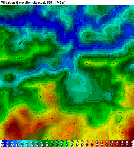
Below is the Elevation map of Wildalpen, which displays elevation range with different colors. Scale of the first map is from 565 to 1743 m (1854 to 5719 ft) with average elevation of 977.9 meters (=3208 ft) [note 1]
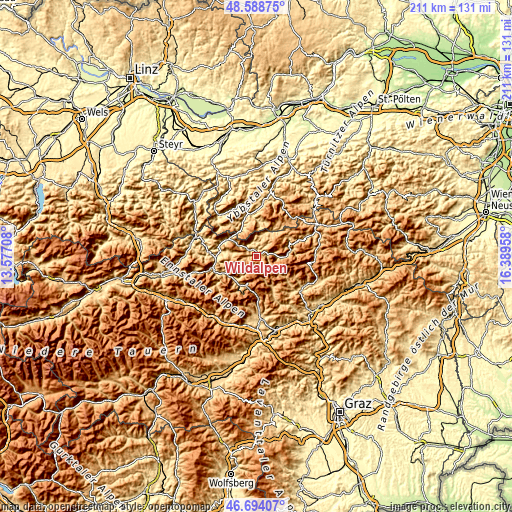
These maps also provides idea of topography and contour of this city, they are displayed at different zoom levels. More info about maps, scale and edge coordinates you can find below images.
| \ | Map #1 | Topo.Map |
| Scale [m] | 565..1743 m | × |
| Scale [ft] | 1854..5719 ft | × |
| Average | 977.9 m = 3208 ft | × |
| Width | 6.58 km = 4.1 mi | 210.7 km = 130.9 mi |
| Height | 6.58 km = 4.1 mi | 210.7 km = 130.9 mi |
| ↑Max Latitude | 47.679596° | 48.58875° |
| Latitude at center | 47.65° | 47.65° |
| ↓Min Latitude | 47.620388° | 46.69407° |
| ← Min Longitude | 14.939385° | 13.57708° |
| Longitude center | 14.98333° | 14.98333° |
| →Max Longitude | 15.027275° | 16.38958° |
Nearby cities:
Cities around Wildalpen sort by population:
• Eisenerz elevation 854 m
15 km,  210°
210°
• Lunz am See 596 m
23.7 km,  8°
8°
• Vordernberg 827 m
18 km,  177°
177°
• Aflenz Kurort 762 m
22.6 km,  122°
122°
• Hieflau 507 m
18.5 km,  254°
254°
• Göstling an der Ybbs 527 m
17.7 km,  348°
348°
• Hollenstein an der Ybbs 484 m
23.2 km,  317°
317°
• Gams bei Hieflau 542 m
15.1 km,  277°
277°
• Palfau 586 m
14.8 km,  292°
292°
• Sankt Ilgen 861 m
17.7 km,  128°
128°
• Thörl 635 m
23.1 km, 128°
• Landl 523 m
18.8 km,  272°
272°
Multilingual:
 En español:
Wildalpen elevación 818 m.
 En France:
Wildalpen élévation 818 m.
 Auf Deutsch:
Wildalpen höhe über dem Meeresspiegel ist 818 m.

Sources and notes:
- [note 1] Map square and city borders are not equal. Map elevation data is calculated only from area inside that square.
- [src 1] Elevation data from geonames database provided with same terms of usage.
- [src 2] The elevation map of Wildalpen is generated using elevation data from NASA's 3 arcsec (90m) resolution SRTM data.
- [src 3] Base (background) map © OpenStreetMap contributors tiles are generated by Geofabrik and OpenTopoMap.
Copyright & License:
This Wildalpen Elevation Map is licensed under CC BY-SA. You may reuse any part from this page, if you give a proper credit by linking to this URL:
 More info on terms of use page.