Thörl elevation
Thörl (Styria, Politischer Bezirk Bruck-Mürzzuschlag), Austria elevation is 635 meters and Thörl elevation in feet is 2083 ft above sea level [src 1]. Thörl is a seat of a third-order administrative division (feature code) with elevation that is 126 meters (413 ft) bigger than average city elevation in Austria.
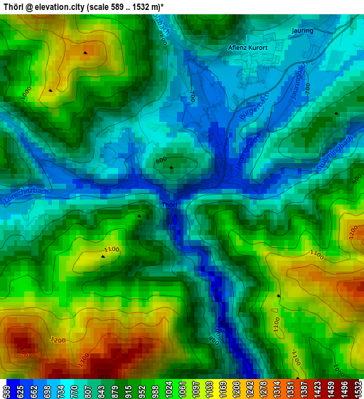
Below is the Elevation map of Thörl, which displays elevation range with different colors. Scale of the first map is from 589 to 1532 m (1932 to 5026 ft) with average elevation of 915.2 meters (=3003 ft) [note 1]
These maps also provides idea of topography and contour of this city, they are displayed at different zoom levels. More info about maps, scale and edge coordinates you can find below images.
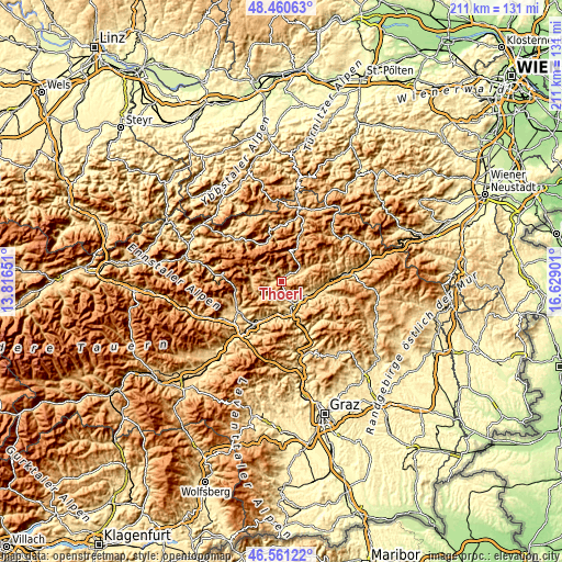
| \ | Map #1 | Topo.Map |
| Scale [m] | 589..1532 m | × |
| Scale [ft] | 1932..5026 ft | × |
| Average | 915.2 m = 3003 ft | × |
| Width | 6.6 km = 4.1 mi | 211.2 km = 131.2 mi |
| Height | 6.6 km = 4.1 mi | 211.2 km = 131.2 mi |
| ↑Max Latitude | 47.54919° | 48.46063° |
| Latitude at center | 47.51952° | 47.51952° |
| ↓Min Latitude | 47.489834° | 46.56122° |
| ← Min Longitude | 15.178815° | 13.81651° |
| Longitude center | 15.22276° | 15.22276° |
| →Max Longitude | 15.266705° | 16.62901° |
Nearby cities:
Cities around Thörl sort by population:
• Hafendorf elevation 525 m
10 km,  134°
134°
• Deuchendorf 545 m
9.5 km, 128°
• Kapfenberg 502 m
9.9 km,  147°
147°
• Berndorf 599 m
11.9 km,  163°
163°
• Sankt Lorenzen im Mürztal 568 m
11.5 km,  110°
110°
• Sankt Martin 514 m
9.3 km, 150°
• Diemlach 493 m
10.1 km, 157°
• Parschlug 702 m
6.4 km, 131°
• Aflenz Kurort 762 m
2.8 km,  25°
25°
• Turnau 750 m
9.6 km,  63°
63°
• Sankt Katharein an der Laming 646 m
7 km,  219°
219°
• Sankt Ilgen 861 m
5.4 km,  308°
308°
Multilingual:
 En español:
Thörl elevación 635 m.
 En France:
Thörl élévation 635 m.


Sources and notes:
- [note 1] Map square and city borders are not equal. Map elevation data is calculated only from area inside that square.
- [src 1] Elevation data from geonames database provided with same terms of usage.
- [src 2] The elevation map of Thörl is generated using elevation data from NASA's 3 arcsec (90m) resolution SRTM data.
- [src 3] Base (background) map © OpenStreetMap contributors tiles are generated by Geofabrik and OpenTopoMap.
Copyright & License:
This Thörl Elevation Map is licensed under CC BY-SA. You may reuse any part from this page, if you give a proper credit by linking to this URL:
 More info on terms of use page.