Hafendorf elevation
Hafendorf (Styria, Politischer Bezirk Bruck-Mürzzuschlag), Austria elevation is 525 meters and Hafendorf elevation in feet is 1722 ft above sea level [src 1]. Hafendorf is a populated place (feature code) with elevation that is 16 meters (52 ft) bigger than average city elevation in Austria.
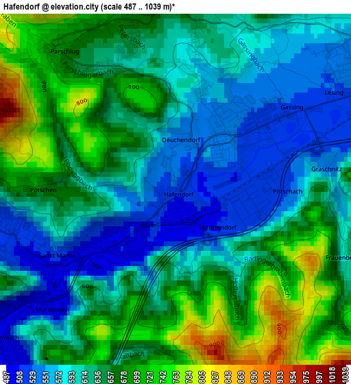
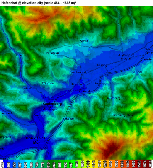
Below is the Elevation map of Hafendorf, which displays elevation range with different colors. Scale of the first map is from 487 to 1039 m (1598 to 3409 ft) with average elevation of 632.4 meters (=2075 ft) [note 1]
These maps also provides idea of topography and contour of this city, they are displayed at different zoom levels. More info about maps, scale and edge coordinates you can find below images.
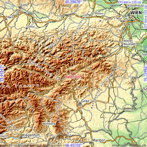
| \ | Map #1 | Map #2 | Topo.Map |
| Scale [m] | 487..1039 m | 464..1618 m | × |
| Scale [ft] | 1598..3409 ft | 1522..5308 ft | × |
| Average | 632.4 m = 2075 ft | 794.9 m = 2608 ft | × |
| Width | 6.61 km = 4.1 mi | 13.22 km = 8.2 mi | 211.4 km = 131.4 mi |
| Height | 6.61 km = 4.1 mi | 13.22 km = 8.2 mi | 211.4 km = 131.4 mi |
| ↑Max Latitude | 47.486235° | 47.515924° | 48.39878° |
| Latitude at center | 47.45653° | 47.45653° | 47.45653° |
| ↓Min Latitude | 47.426808° | 47.397069° | 46.49709° |
| ← Min Longitude | 15.274425° | 15.230479° | 13.91212° |
| Longitude center | 15.31837° | 15.31837° | 15.31837° |
| →Max Longitude | 15.362315° | 15.406261° | 16.72462° |
Nearby cities:
Cities around Hafendorf sort by population:
• Bruck an der Mur elevation 572 m
5.2 km,  210°
210°
• Deuchendorf 545 m
1.1 km,  13°
13°
• Kapfenberg 502 m
2.3 km,  234°
234°
• Berndorf 599 m
5.9 km,  221°
221°
• Sankt Lorenzen im Mürztal 568 m
4.7 km,  50°
50°
• Sankt Martin 514 m
2.7 km,  246°
246°
• Diemlach 493 m
4 km,  235°
235°
• Sankt Marein im Mürztal 523 m
3.8 km,  72°
72°
• Parschlug 702 m
3.6 km,  318°
318°
• Mürzhofen 542 m
5.7 km,  58°
58°
• Allerheiligen im Mürztal 701 m
6.2 km,  79°
79°
• Frauenberg 930 m
3.6 km,  150°
150°
Multilingual:
 En español:
Hafendorf elevación 525 m.
 En France:
Hafendorf élévation 525 m.
 Auf Deutsch:
Hafendorf höhe über dem Meeresspiegel ist 525 m.

Sources and notes:
- [note 1] Map square and city borders are not equal. Map elevation data is calculated only from area inside that square.
- [src 1] Elevation data from geonames database provided with same terms of usage.
- [src 2] The elevation map of Hafendorf is generated using elevation data from NASA's 3 arcsec (90m) resolution SRTM data.
- [src 3] Base (background) map © OpenStreetMap contributors tiles are generated by Geofabrik and OpenTopoMap.
Copyright & License:
This Hafendorf Elevation Map is licensed under CC BY-SA. You may reuse any part from this page, if you give a proper credit by linking to this URL:
 More info on terms of use page.