Bruck an der Mur elevation
Bruck an der Mur (Styria, Politischer Bezirk Bruck-Mürzzuschlag), Austria elevation is 572 meters and Bruck an der Mur elevation in feet is 1877 ft above sea level [src 1]. Bruck an der Mur is a seat of a third-order administrative division (feature code) with elevation that is 63 meters (207 ft) bigger than average city elevation in Austria.
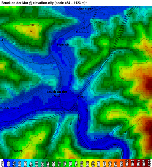
Below is the Elevation map of Bruck an der Mur, which displays elevation range with different colors. Scale of the first map is from 464 to 1123 m (1522 to 3684 ft) with average elevation of 640.9 meters (=2103 ft) [note 1]
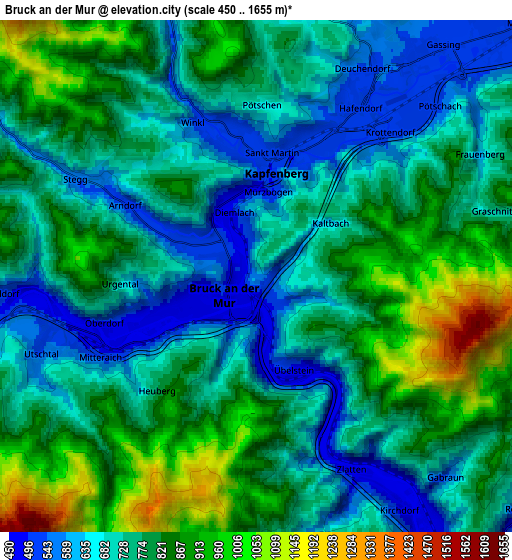
These maps also provides idea of topography and contour of this city, they are displayed at different zoom levels. More info about maps, scale and edge coordinates you can find below images.
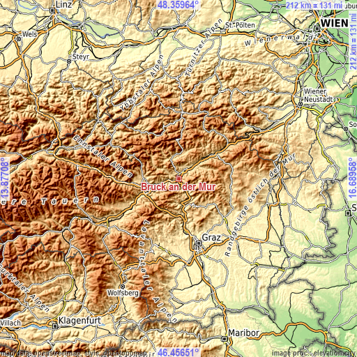
| \ | Map #1 | Map #2 | Topo.Map |
| Scale [m] | 464..1123 m | 450..1655 m | × |
| Scale [ft] | 1522..3684 ft | 1476..5430 ft | × |
| Average | 640.9 m = 2103 ft | 766 m = 2513 ft | × |
| Width | 6.61 km = 4.1 mi | 13.23 km = 8.2 mi | 211.6 km = 131.5 mi |
| Height | 6.61 km = 4.1 mi | 13.23 km = 8.2 mi | 211.6 km = 131.5 mi |
| ↑Max Latitude | 47.446398° | 47.476109° | 48.35964° |
| Latitude at center | 47.41667° | 47.41667° | 47.41667° |
| ↓Min Latitude | 47.386925° | 47.357164° | 46.45651° |
| ← Min Longitude | 15.239385° | 15.195439° | 13.87708° |
| Longitude center | 15.28333° | 15.28333° | 15.28333° |
| →Max Longitude | 15.327275° | 15.371221° | 16.68958° |
Nearby cities:
Cities around Bruck an der Mur sort by population:
• Hafendorf elevation 525 m
5.2 km,  30°
30°
• Deuchendorf 545 m
6.2 km, 27°
• Kapfenberg 502 m
3.2 km,  13°
13°
• Berndorf 599 m
1.3 km,  270°
270°
• Sankt Martin 514 m
3.3 km,  2°
2°
• Diemlach 493 m
2.3 km,  343°
343°
• Sankt Marein im Mürztal 523 m
8.4 km,  48°
48°
• Utschtal 664 m
6.5 km,  253°
253°
• Parschlug 702 m
7.1 km, 1°
• Pernegg an der Mur 458 m
7.7 km,  144°
144°
• Oberaich 536 m
5.3 km, 249°
• Frauenberg 930 m
4.6 km,  73°
73°
Multilingual:
 En español:
Bruck an der Mur elevación 572 m.
 En France:
Bruck an der Mur élévation 572 m.
 Auf Deutsch:
Bruck an der Mur höhe über dem Meeresspiegel ist 572 m.
 На русском:
Брук-ан-дер-Мур, Брукк-ан-дер-Мур высота над уровнем моря 572 м
Sources and notes:
- [note 1] Map square and city borders are not equal. Map elevation data is calculated only from area inside that square.
- [src 1] Elevation data from geonames database provided with same terms of usage.
- [src 2] The elevation map of Bruck an der Mur is generated using elevation data from NASA's 3 arcsec (90m) resolution SRTM data.
- [src 3] Base (background) map © OpenStreetMap contributors tiles are generated by Geofabrik and OpenTopoMap.
Copyright & License:
This Bruck an der Mur Elevation Map is licensed under CC BY-SA. You may reuse any part from this page, if you give a proper credit by linking to this URL:
 More info on terms of use page.