Palfau elevation
Palfau (Styria, Politischer Bezirk Liezen), Austria elevation is 586 meters and Palfau elevation in feet is 1923 ft above sea level [src 1]. Palfau is a seat of a third-order administrative division (feature code) with elevation that is 77 meters (253 ft) bigger than average city elevation in Austria.
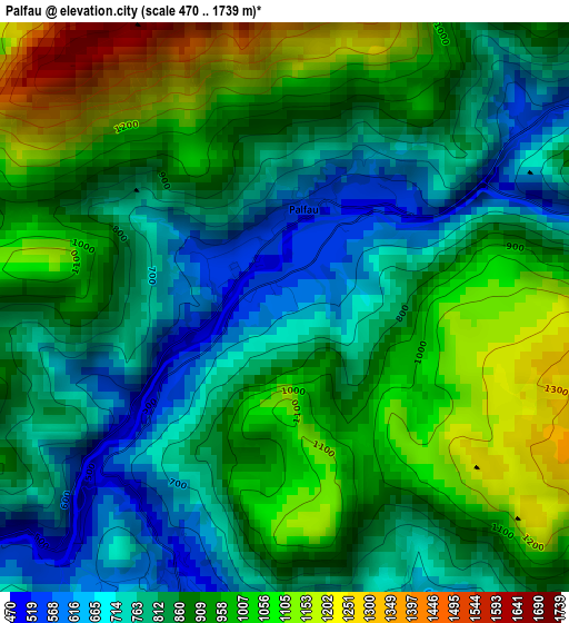
Below is the Elevation map of Palfau, which displays elevation range with different colors. Scale of the first map is from 470 to 1739 m (1542 to 5705 ft) with average elevation of 882.2 meters (=2894 ft) [note 1]
These maps also provides idea of topography and contour of this city, they are displayed at different zoom levels. More info about maps, scale and edge coordinates you can find below images.
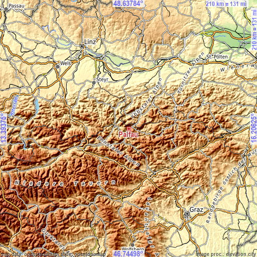
| \ | Map #1 | Topo.Map |
| Scale [m] | 470..1739 m | × |
| Scale [ft] | 1542..5705 ft | × |
| Average | 882.2 m = 2894 ft | × |
| Width | 6.58 km = 4.1 mi | 210.5 km = 130.8 mi |
| Height | 6.58 km = 4.1 mi | 210.5 km = 130.8 mi |
| ↑Max Latitude | 47.729567° | 48.63784° |
| Latitude at center | 47.7° | 47.7° |
| ↓Min Latitude | 47.670416° | 46.74498° |
| ← Min Longitude | 14.756055° | 13.39375° |
| Longitude center | 14.8° | 14.8° |
| →Max Longitude | 14.843945° | 16.20625° |
Nearby cities:
Cities around Palfau sort by population:
• Eisenerz elevation 854 m
19.6 km,  161°
161°
• Weyer 404 m
20.2 km,  329°
329°
• Sankt Gallen 516 m
13.8 km,  263°
263°
• Altenmarkt bei Sankt Gallen 469 m
11.6 km,  282°
282°
• Gaflenz 476 m
22.4 km,  345°
345°
• Hieflau 507 m
11.2 km,  201°
201°
• Göstling an der Ybbs 527 m
15.7 km,  41°
41°
• Hollenstein an der Ybbs 484 m
11.6 km, 350°
• Gams bei Hieflau 542 m
3.9 km, 198°
• Wildalpen 818 m
14.8 km,  112°
112°
• Opponitz 415 m
19.8 km,  4°
4°
• Landl 523 m
7 km,  226°
226°
Multilingual:
 En español:
Palfau elevación 586 m.
 En France:
Palfau élévation 586 m.


Sources and notes:
- [note 1] Map square and city borders are not equal. Map elevation data is calculated only from area inside that square.
- [src 1] Elevation data from geonames database provided with same terms of usage.
- [src 2] The elevation map of Palfau is generated using elevation data from NASA's 3 arcsec (90m) resolution SRTM data.
- [src 3] Base (background) map © OpenStreetMap contributors tiles are generated by Geofabrik and OpenTopoMap.
Copyright & License:
This Palfau Elevation Map is licensed under CC BY-SA. You may reuse any part from this page, if you give a proper credit by linking to this URL:
 More info on terms of use page.