Windischgarsten elevation
Windischgarsten (Upper Austria, Politischer Bezirk Kirchdorf an der Krems), Austria elevation is 602 meters and Windischgarsten elevation in feet is 1975 ft above sea level [src 1]. Windischgarsten is a populated place (feature code) with elevation that is 93 meters (305 ft) bigger than average city elevation in Austria.
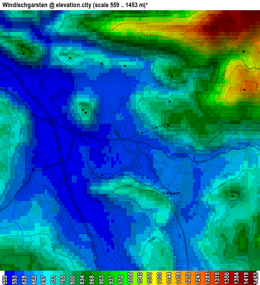
Below is the Elevation map of Windischgarsten, which displays elevation range with different colors. Scale of the first map is from 559 to 1453 m (1834 to 4767 ft) with average elevation of 736.4 meters (=2416 ft) [note 1]
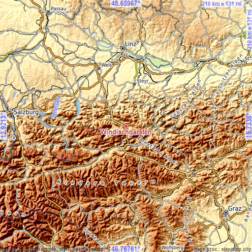
These maps also provides idea of topography and contour of this city, they are displayed at different zoom levels. More info about maps, scale and edge coordinates you can find below images.
| \ | Map #1 | Topo.Map |
| Scale [m] | 559..1453 m | × |
| Scale [ft] | 1834..4767 ft | × |
| Average | 736.4 m = 2416 ft | × |
| Width | 6.57 km = 4.1 mi | 210.4 km = 130.7 mi |
| Height | 6.57 km = 4.1 mi | 210.4 km = 130.7 mi |
| ↑Max Latitude | 47.751785° | 48.65967° |
| Latitude at center | 47.72223° | 47.72223° |
| ↓Min Latitude | 47.692658° | 46.76761° |
| ← Min Longitude | 14.283605° | 12.9213° |
| Longitude center | 14.32755° | 14.32755° |
| →Max Longitude | 14.371495° | 15.7338° |
Nearby cities:
Cities around Windischgarsten sort by population:
• Liezen elevation 642 m
18.7 km,  202°
202°
• Molln 421 m
19.1 km,  344°
344°
• Admont 642 m
19.1 km,  148°
148°
• Leonstein 417 m
20.7 km, 339°
• Hall bei Admont 634 m
18.2 km, 145°
• Spital am Pyhrn 644 m
6.4 km,  171°
171°
• Weißenbach bei Liezen 635 m
19.2 km,  205°
205°
• Reichraming 359 m
20.1 km,  27°
27°
• Selzthal 634 m
19.2 km,  183°
183°
• Ardning 664 m
14.8 km, 169°
• Lassing 735 m
21.6 km,  193°
193°
• Klausner 642 m
16.4 km, 174°
Multilingual:
 En español:
Windischgarsten elevación 602 m.
 En France:
Windischgarsten élévation 602 m.
 Auf Deutsch:
Windischgarsten höhe über dem Meeresspiegel ist 602 m.

Sources and notes:
- [note 1] Map square and city borders are not equal. Map elevation data is calculated only from area inside that square.
- [src 1] Elevation data from geonames database provided with same terms of usage.
- [src 2] The elevation map of Windischgarsten is generated using elevation data from NASA's 3 arcsec (90m) resolution SRTM data.
- [src 3] Base (background) map © OpenStreetMap contributors tiles are generated by Geofabrik and OpenTopoMap.
Copyright & License:
This Windischgarsten Elevation Map is licensed under CC BY-SA. You may reuse any part from this page, if you give a proper credit by linking to this URL:
 More info on terms of use page.