Molln elevation
Molln (Upper Austria, Politischer Bezirk Kirchdorf an der Krems), Austria elevation is 421 meters and Molln elevation in feet is 1381 ft above sea level [src 1]. Molln is a populated place (feature code) with elevation that is 88 meters (289 ft) smaller than average city elevation in Austria.
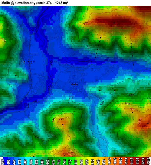
Below is the Elevation map of Molln, which displays elevation range with different colors. Scale of the first map is from 374 to 1248 m (1227 to 4094 ft) with average elevation of 617.8 meters (=2027 ft) [note 1]
These maps also provides idea of topography and contour of this city, they are displayed at different zoom levels. More info about maps, scale and edge coordinates you can find below images.
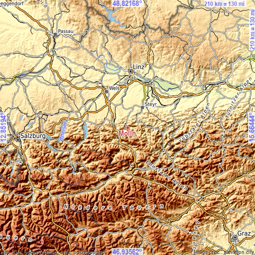
| \ | Map #1 | Topo.Map |
| Scale [m] | 374..1248 m | × |
| Scale [ft] | 1227..4094 ft | × |
| Average | 617.8 m = 2027 ft | × |
| Width | 6.55 km = 4.1 mi | 209.7 km = 130.3 mi |
| Height | 6.55 km = 4.1 mi | 209.7 km = 130.3 mi |
| ↑Max Latitude | 47.916691° | 48.82168° |
| Latitude at center | 47.88723° | 47.88723° |
| ↓Min Latitude | 47.857752° | 46.93562° |
| ← Min Longitude | 14.214245° | 12.85194° |
| Longitude center | 14.25819° | 14.25819° |
| →Max Longitude | 14.302135° | 15.66444° |
Nearby cities:
Cities around Molln sort by population:
• Micheldorf in Oberösterreich elevation 459 m
9.4 km,  263°
263°
• Kirchdorf an der Krems 446 m
10.3 km,  281°
281°
• Grünburg 359 m
9.5 km,  2°
2°
• Ternberg 342 m
9.9 km,  49°
49°
• Adlwang 413 m
12.1 km,  345°
345°
• Schlierbach 409 m
11.6 km,  297°
297°
• Leonstein 417 m
2.3 km, 297°
• Aschach an der Steyr 426 m
15.1 km,  22°
22°
• Losenstein 399 m
13.9 km,  72°
72°
• Waldneukirchen 431 m
12.4 km, 0°
• Inzersdorf im Kremstal 434 m
14 km,  288°
288°
• Reichraming 359 m
14.3 km,  91°
91°
Multilingual:
 En español:
Molln elevación 421 m.
 En France:
Molln élévation 421 m.


Sources and notes:
- [note 1] Map square and city borders are not equal. Map elevation data is calculated only from area inside that square.
- [src 1] Elevation data from geonames database provided with same terms of usage.
- [src 2] The elevation map of Molln is generated using elevation data from NASA's 3 arcsec (90m) resolution SRTM data.
- [src 3] Base (background) map © OpenStreetMap contributors tiles are generated by Geofabrik and OpenTopoMap.
Copyright & License:
This Molln Elevation Map is licensed under CC BY-SA. You may reuse any part from this page, if you give a proper credit by linking to this URL:
 More info on terms of use page.