Micheldorf in Oberösterreich elevation
Micheldorf in Oberösterreich (Upper Austria, Politischer Bezirk Kirchdorf an der Krems), Austria elevation is 459 meters and Micheldorf in Oberösterreich elevation in feet is 1506 ft above sea level [src 1]. Micheldorf in Oberösterreich is a populated place (feature code) with elevation that is 50 meters (164 ft) smaller than average city elevation in Austria.
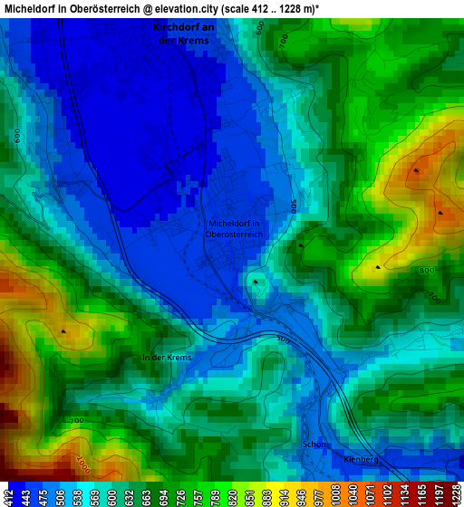
Below is the Elevation map of Micheldorf in Oberösterreich, which displays elevation range with different colors. Scale of the first map is from 412 to 1228 m (1352 to 4029 ft) with average elevation of 622.9 meters (=2044 ft) [note 1]
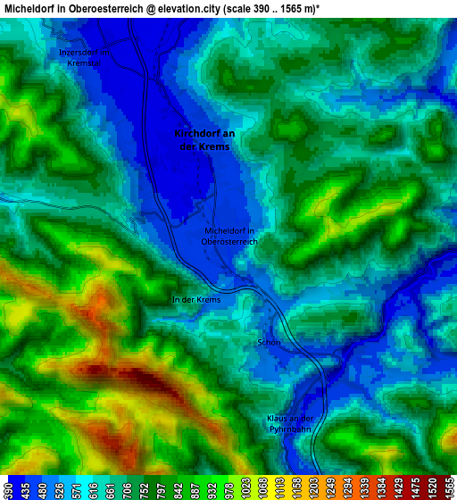
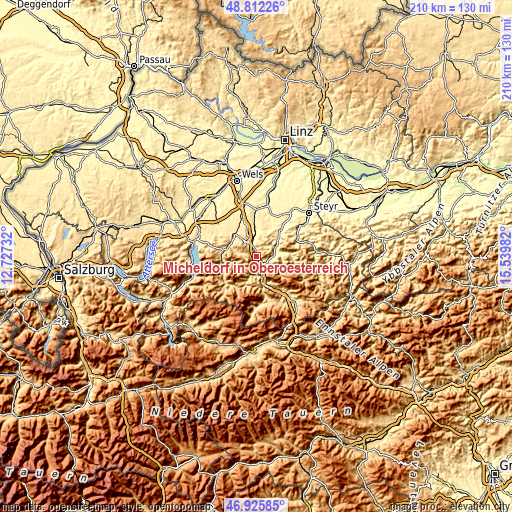
These maps also provides idea of topography and contour of this city, they are displayed at different zoom levels. More info about maps, scale and edge coordinates you can find below images.
| \ | Map #1 | Map #2 | Topo.Map |
| Scale [m] | 412..1228 m | 390..1565 m | × |
| Scale [ft] | 1352..4029 ft | 1280..5135 ft | × |
| Average | 622.9 m = 2044 ft | 713 m = 2339 ft | × |
| Width | 6.55 km = 4.1 mi | 13.11 km = 8.1 mi | 209.7 km = 130.3 mi |
| Height | 6.55 km = 4.1 mi | 13.11 km = 8.1 mi | 209.7 km = 130.3 mi |
| ↑Max Latitude | 47.907106° | 47.936556° | 48.81226° |
| Latitude at center | 47.87764° | 47.87764° | 47.87764° |
| ↓Min Latitude | 47.848157° | 47.818657° | 46.92585° |
| ← Min Longitude | 14.089625° | 14.045679° | 12.72732° |
| Longitude center | 14.13357° | 14.13357° | 14.13357° |
| →Max Longitude | 14.177515° | 14.221461° | 15.53982° |
Nearby cities:
Cities around Micheldorf in Oberösterreich sort by population:
• Kirchdorf an der Krems elevation 446 m
3.2 km,  344°
344°
• Molln 421 m
9.4 km,  83°
83°
• Grünau im Almtal 516 m
13.5 km,  259°
259°
• Adlwang 413 m
14.2 km,  26°
26°
• Schlierbach 409 m
6.6 km,  351°
351°
• Leonstein 417 m
7.6 km,  73°
73°
• Pettenbach 486 m
12.6 km,  316°
316°
• Mühldorf 522 m
13.8 km,  278°
278°
• Wartberg an der Krems 378 m
12.4 km, 354°
• Viechtwang 504 m
13.4 km,  288°
288°
• Scharnstein 512 m
13.2 km, 282°
• Inzersdorf im Kremstal 434 m
6.8 km,  325°
325°
Multilingual:
 En español:
Micheldorf in Oberösterreich elevación 459 m.
 En France:
Micheldorf in Oberösterreich élévation 459 m.
 Auf Deutsch:
Micheldorf in Oberösterreich höhe über dem Meeresspiegel ist 459 m.
 На русском:
Михельдорф (Верхняя Австрия), Михельдорф высота над уровнем моря 459 м
Sources and notes:
- [note 1] Map square and city borders are not equal. Map elevation data is calculated only from area inside that square.
- [src 1] Elevation data from geonames database provided with same terms of usage.
- [src 2] The elevation map of Micheldorf in Oberösterreich is generated using elevation data from NASA's 3 arcsec (90m) resolution SRTM data.
- [src 3] Base (background) map © OpenStreetMap contributors tiles are generated by Geofabrik and OpenTopoMap.
Copyright & License:
This Micheldorf in Oberösterreich Elevation Map is licensed under CC BY-SA. You may reuse any part from this page, if you give a proper credit by linking to this URL:
 More info on terms of use page.