Hall bei Admont elevation
Hall bei Admont (Styria, Politischer Bezirk Liezen), Austria elevation is 634 meters and Hall bei Admont elevation in feet is 2080 ft above sea level [src 1]. Hall bei Admont is a seat of a third-order administrative division (feature code) with elevation that is 125 meters (410 ft) bigger than average city elevation in Austria.
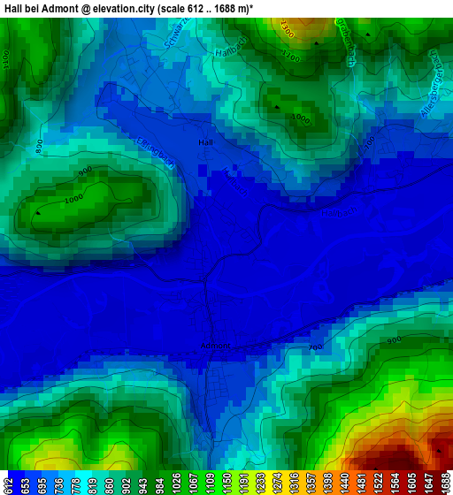
Below is the Elevation map of Hall bei Admont, which displays elevation range with different colors. Scale of the first map is from 612 to 1688 m (2008 to 5538 ft) with average elevation of 812.7 meters (=2666 ft) [note 1]
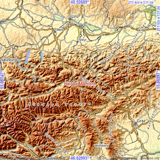
These maps also provides idea of topography and contour of this city, they are displayed at different zoom levels. More info about maps, scale and edge coordinates you can find below images.
| \ | Map #1 | Topo.Map |
| Scale [m] | 612..1688 m | × |
| Scale [ft] | 2008..5538 ft | × |
| Average | 812.7 m = 2666 ft | × |
| Width | 6.59 km = 4.1 mi | 210.9 km = 131 mi |
| Height | 6.59 km = 4.1 mi | 210.9 km = 131 mi |
| ↑Max Latitude | 47.616631° | 48.52689° |
| Latitude at center | 47.587° | 47.587° |
| ↓Min Latitude | 47.557352° | 46.62993° |
| ← Min Longitude | 14.419775° | 13.05747° |
| Longitude center | 14.46372° | 14.46372° |
| →Max Longitude | 14.507665° | 15.86997° |
Nearby cities:
Cities around Hall bei Admont sort by population:
• Trieben elevation 683 m
11.4 km,  171°
171°
• Rottenmann 883 m
11.6 km,  227°
227°
• Admont 642 m
1.3 km,  189°
189°
• Spital am Pyhrn 644 m
12.7 km,  313°
313°
• Selzthal 634 m
12.1 km,  250°
250°
• Ardning 664 m
7.5 km,  273°
273°
• Sankt Gallen 516 m
15.9 km,  46°
46°
• Treglwang 730 m
15.7 km,  142°
142°
• Hohentauern 1274 m
17.1 km,  175°
175°
• Johnsbach 1067 m
10.8 km,  123°
123°
• Lassing 735 m
16.5 km, 249°
• Klausner 642 m
8.6 km,  261°
261°
Multilingual:
 En español:
Hall bei Admont elevación 634 m.
 En France:
Hall bei Admont élévation 634 m.
 Auf Deutsch:
Hall bei Admont höhe über dem Meeresspiegel ist 634 m.

Sources and notes:
- [note 1] Map square and city borders are not equal. Map elevation data is calculated only from area inside that square.
- [src 1] Elevation data from geonames database provided with same terms of usage.
- [src 2] The elevation map of Hall bei Admont is generated using elevation data from NASA's 3 arcsec (90m) resolution SRTM data.
- [src 3] Base (background) map © OpenStreetMap contributors tiles are generated by Geofabrik and OpenTopoMap.
Copyright & License:
This Hall bei Admont Elevation Map is licensed under CC BY-SA. You may reuse any part from this page, if you give a proper credit by linking to this URL:
 More info on terms of use page.