Zagersdorf elevation
Zagersdorf (Burgenland, Eisenstadt-Umgebung), Austria elevation is 179 meters and Zagersdorf elevation in feet is 587 ft above sea level [src 1]. Zagersdorf is a seat of a third-order administrative division (feature code) with elevation that is 330 meters (1083 ft) smaller than average city elevation in Austria.
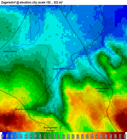
Below is the Elevation map of Zagersdorf, which displays elevation range with different colors. Scale of the first map is from 152 to 322 m (499 to 1056 ft) with average elevation of 209.7 meters (=688 ft) [note 1]
These maps also provides idea of topography and contour of this city, they are displayed at different zoom levels. More info about maps, scale and edge coordinates you can find below images.
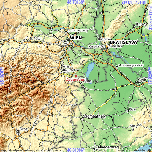
| \ | Map #1 | Topo.Map |
| Scale [m] | 152..322 m | × |
| Scale [ft] | 499..1056 ft | × |
| Average | 209.7 m = 688 ft | × |
| Width | 6.57 km = 4.1 mi | 210.2 km = 130.6 mi |
| Height | 6.57 km = 4.1 mi | 210.2 km = 130.6 mi |
| ↑Max Latitude | 47.794241° | 48.70138° |
| Latitude at center | 47.76471° | 47.76471° |
| ↓Min Latitude | 47.735163° | 46.81086° |
| ← Min Longitude | 16.469875° | 15.10757° |
| Longitude center | 16.51382° | 16.51382° |
| →Max Longitude | 16.557765° | 17.92007° |
Nearby cities:
Cities around Zagersdorf sort by population:
• Siegendorf im Burgenland elevation 162 m
2.8 km,  49°
49°
• Sankt Margarethen im Burgenland 147 m
8.3 km,  58°
58°
• Schattendorf 250 m
6.1 km,  182°
182°
• Trausdorf an der Wulka 153 m
6.3 km,  31°
31°
• Wulkaprodersdorf 167 m
3.7 km,  349°
349°
• Loipersbach im Burgenland 285 m
8 km,  198°
198°
• Drassburg 233 m
2.9 km,  224°
224°
• Klingenbach 239 m
2.5 km,  125°
125°
• Hirm 180 m
5 km,  298°
298°
• Antau 185 m
2.7 km,  291°
291°
• Pöttelsdorf 209 m
5.8 km,  257°
257°
• Krensdorf 194 m
7.7 km, 287°
Multilingual:
 En español:
Zagersdorf elevación 179 m.
 En France:
Zagersdorf élévation 179 m.
 Auf Deutsch:
Zagersdorf höhe über dem Meeresspiegel ist 179 m.

Sources and notes:
- [note 1] Map square and city borders are not equal. Map elevation data is calculated only from area inside that square.
- [src 1] Elevation data from geonames database provided with same terms of usage.
- [src 2] The elevation map of Zagersdorf is generated using elevation data from NASA's 3 arcsec (90m) resolution SRTM data.
- [src 3] Base (background) map © OpenStreetMap contributors tiles are generated by Geofabrik and OpenTopoMap.
Copyright & License:
This Zagersdorf Elevation Map is licensed under CC BY-SA. You may reuse any part from this page, if you give a proper credit by linking to this URL:
 More info on terms of use page.